You are here: Home > Network List > TA - USArray Transportable Network (new EarthScope stations) Stations List
> Station O06A Flanigan, NV, USA > Earthquake Result Viewer
O06A Flanigan, NV, USA - Earthquake Result Viewer
| Earthquake location: |
San Juan Province, Argentina |
| Earthquake latitude/longitude: |
-31.7/-67.2 |
| Earthquake time(UTC): |
2006/09/17 (260) 09:34:14 GMT |
| Earthquake Depth: |
142 km |
| Earthquake Magnitude: |
5.7 MB, 6.2 MW, 6.2 MW |
| Earthquake Catalog/Contributor: |
WHDF/NEIC |
|
| Network: |
TA USArray Transportable Network (new EarthScope stations) |
| Station: |
O06A Flanigan, NV, USA |
| Lat/Lon: |
40.17 N/119.83 W |
| Elevation: |
1229 m |
|
| Distance: |
86.6 deg |
| Az: |
322.39 deg |
| Baz: |
137.274 deg |
| Ray Param: |
0.043631863 |
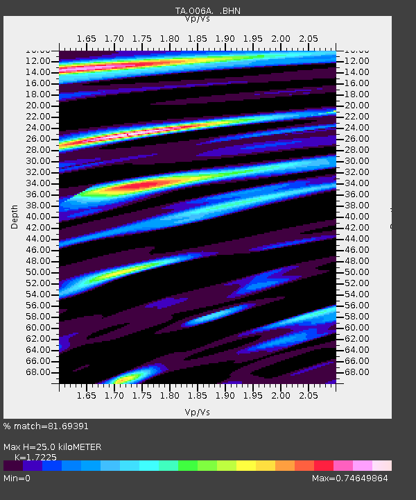
| Estimated Moho Depth: |
25.0 km |
| Estimated Crust Vp/Vs: |
1.72 |
| Assumed Crust Vp: |
6.276 km/s |
| Estimated Crust Vs: |
3.643 km/s |
| Estimated Crust Poisson's Ratio: |
0.25 |
|
| Radial Match: |
81.69391 % |
| Radial Bump: |
400 |
| Transverse Match: |
77.716606 % |
| Transverse Bump: |
400 |
| SOD ConfigId: |
2665 |
| Insert Time: |
2010-03-07 01:14:37.697 +0000 |
| GWidth: |
2.5 |
| Max Bumps: |
400 |
| Tol: |
0.001 |
|
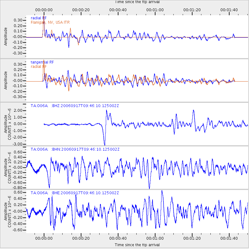
Signal To Noise
| Channel | StoN | STA | LTA |
| TA:O06A: :BHN:20060917T09:46:10.125002Z | 1.8622487 | 3.1516518E-7 | 1.6923904E-7 |
| TA:O06A: :BHE:20060917T09:46:10.125002Z | 2.333743 | 2.504227E-7 | 1.0730516E-7 |
| TA:O06A: :BHZ:20060917T09:46:10.125002Z | 23.36545 | 1.3446574E-6 | 5.7548966E-8 |
| Arrivals |
| Ps | 2.9 SECOND |
| PpPs | 11 SECOND |
| PsPs/PpSs | 14 SECOND |


