You are here: Home > Network List > TA - USArray Transportable Network (new EarthScope stations) Stations List
> Station O06A Flanigan, NV, USA > Earthquake Result Viewer
O06A Flanigan, NV, USA - Earthquake Result Viewer
| Earthquake location: |
Solomon Islands |
| Earthquake latitude/longitude: |
-6.8/155.5 |
| Earthquake time(UTC): |
2006/09/01 (244) 10:18:51 GMT |
| Earthquake Depth: |
38 km |
| Earthquake Magnitude: |
6.3 MB, 6.7 MS, 6.8 MW, 6.7 MW |
| Earthquake Catalog/Contributor: |
WHDF/NEIC |
|
| Network: |
TA USArray Transportable Network (new EarthScope stations) |
| Station: |
O06A Flanigan, NV, USA |
| Lat/Lon: |
40.17 N/119.83 W |
| Elevation: |
1229 m |
|
| Distance: |
90.2 deg |
| Az: |
49.73 deg |
| Baz: |
261.433 deg |
| Ray Param: |
0.041682046 |
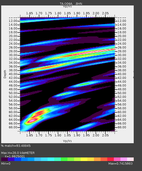
| Estimated Moho Depth: |
28.0 km |
| Estimated Crust Vp/Vs: |
1.99 |
| Assumed Crust Vp: |
6.276 km/s |
| Estimated Crust Vs: |
3.15 km/s |
| Estimated Crust Poisson's Ratio: |
0.33 |
|
| Radial Match: |
93.48845 % |
| Radial Bump: |
400 |
| Transverse Match: |
84.37746 % |
| Transverse Bump: |
400 |
| SOD ConfigId: |
2665 |
| Insert Time: |
2010-03-07 01:14:42.369 +0000 |
| GWidth: |
2.5 |
| Max Bumps: |
400 |
| Tol: |
0.001 |
|
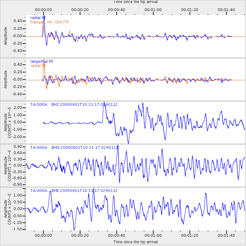
Signal To Noise
| Channel | StoN | STA | LTA |
| TA:O06A: :BHN:20060901T10:31:17.024011Z | 1.3066274 | 9.9088595E-8 | 7.583539E-8 |
| TA:O06A: :BHE:20060901T10:31:17.024011Z | 7.3238077 | 6.068699E-7 | 8.286262E-8 |
| TA:O06A: :BHZ:20060901T10:31:17.024011Z | 19.978659 | 1.3217259E-6 | 6.615689E-8 |
| Arrivals |
| Ps | 4.5 SECOND |
| PpPs | 13 SECOND |
| PsPs/PpSs | 18 SECOND |


