You are here: Home > Network List > TA - USArray Transportable Network (new EarthScope stations) Stations List
> Station Q18K Katmai Hardscrabble Creek, AK, USA > Earthquake Result Viewer
Q18K Katmai Hardscrabble Creek, AK, USA - Earthquake Result Viewer
| Earthquake location: |
Solomon Islands |
| Earthquake latitude/longitude: |
-6.3/154.7 |
| Earthquake time(UTC): |
2019/07/06 (187) 09:44:29 GMT |
| Earthquake Depth: |
43 km |
| Earthquake Magnitude: |
5.5 Mww |
| Earthquake Catalog/Contributor: |
NEIC PDE/us |
|
| Network: |
TA USArray Transportable Network (new EarthScope stations) |
| Station: |
Q18K Katmai Hardscrabble Creek, AK, USA |
| Lat/Lon: |
58.65 N/155.01 W |
| Elevation: |
1250 m |
|
| Distance: |
76.1 deg |
| Az: |
24.468 deg |
| Baz: |
231.955 deg |
| Ray Param: |
0.051133752 |
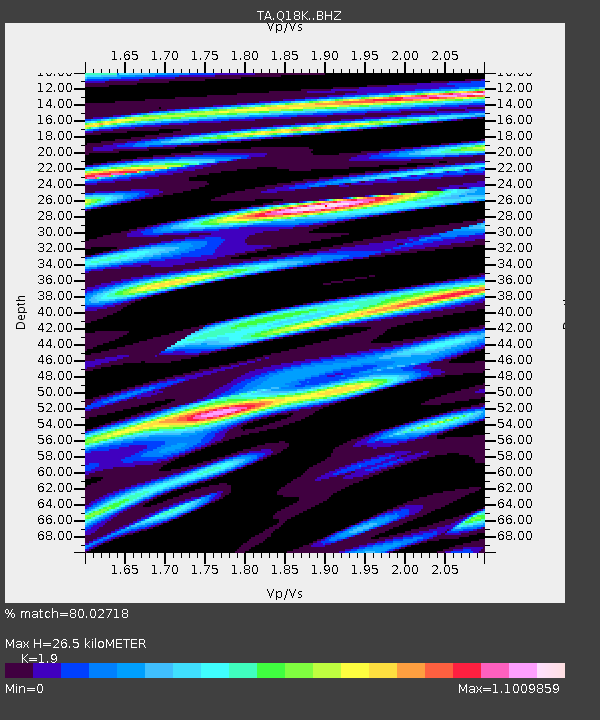
| Estimated Moho Depth: |
26.5 km |
| Estimated Crust Vp/Vs: |
1.90 |
| Assumed Crust Vp: |
6.438 km/s |
| Estimated Crust Vs: |
3.389 km/s |
| Estimated Crust Poisson's Ratio: |
0.31 |
|
| Radial Match: |
80.02718 % |
| Radial Bump: |
400 |
| Transverse Match: |
80.71469 % |
| Transverse Bump: |
400 |
| SOD ConfigId: |
19053131 |
| Insert Time: |
2019-07-20 09:52:04.893 +0000 |
| GWidth: |
2.5 |
| Max Bumps: |
400 |
| Tol: |
0.001 |
|

Signal To Noise
| Channel | StoN | STA | LTA |
| TA:Q18K: :BHZ:20190706T09:55:42.175026Z | 8.260282 | 5.590534E-7 | 6.767969E-8 |
| TA:Q18K: :BHN:20190706T09:55:42.175026Z | 4.3906126 | 2.853966E-7 | 6.5001544E-8 |
| TA:Q18K: :BHE:20190706T09:55:42.175026Z | 2.3964417 | 2.210668E-7 | 9.224794E-8 |
| Arrivals |
| Ps | 3.8 SECOND |
| PpPs | 12 SECOND |
| PsPs/PpSs | 15 SECOND |


