You are here: Home > Network List > TA - USArray Transportable Network (new EarthScope stations) Stations List
> Station R33M Jennings River, BC, CAN > Earthquake Result Viewer
R33M Jennings River, BC, CAN - Earthquake Result Viewer
| Earthquake location: |
Solomon Islands |
| Earthquake latitude/longitude: |
-6.3/154.7 |
| Earthquake time(UTC): |
2019/07/06 (187) 09:44:29 GMT |
| Earthquake Depth: |
43 km |
| Earthquake Magnitude: |
5.5 Mww |
| Earthquake Catalog/Contributor: |
NEIC PDE/us |
|
| Network: |
TA USArray Transportable Network (new EarthScope stations) |
| Station: |
R33M Jennings River, BC, CAN |
| Lat/Lon: |
59.39 N/130.97 W |
| Elevation: |
1437 m |
|
| Distance: |
87.5 deg |
| Az: |
29.543 deg |
| Baz: |
253.34 deg |
| Ray Param: |
0.04325271 |
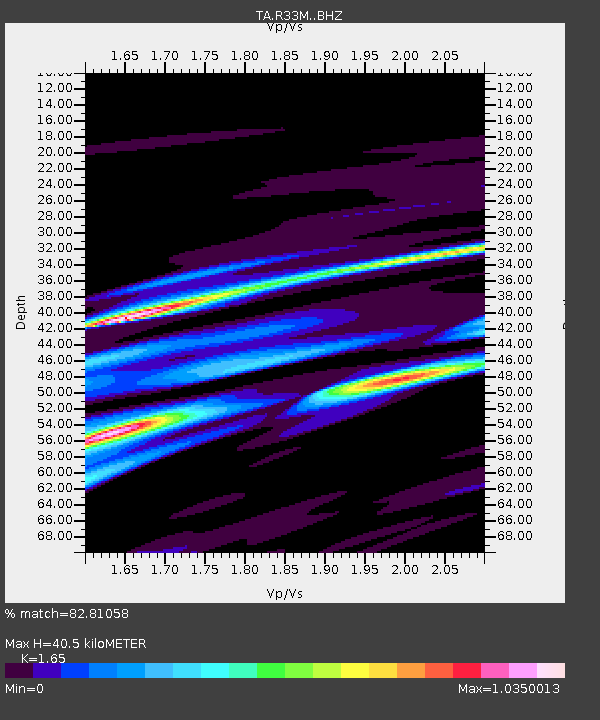
| Estimated Moho Depth: |
40.5 km |
| Estimated Crust Vp/Vs: |
1.65 |
| Assumed Crust Vp: |
6.597 km/s |
| Estimated Crust Vs: |
3.998 km/s |
| Estimated Crust Poisson's Ratio: |
0.21 |
|
| Radial Match: |
82.81058 % |
| Radial Bump: |
400 |
| Transverse Match: |
75.478165 % |
| Transverse Bump: |
400 |
| SOD ConfigId: |
19053131 |
| Insert Time: |
2019-07-20 09:52:08.865 +0000 |
| GWidth: |
2.5 |
| Max Bumps: |
400 |
| Tol: |
0.001 |
|

Signal To Noise
| Channel | StoN | STA | LTA |
| TA:R33M: :BHZ:20190706T09:56:41.525002Z | 2.4392815 | 3.4656608E-7 | 1.4207713E-7 |
| TA:R33M: :BHN:20190706T09:56:41.525002Z | 1.2056633 | 8.843883E-8 | 7.3352844E-8 |
| TA:R33M: :BHE:20190706T09:56:41.525002Z | 1.6798353 | 1.7662434E-7 | 1.0514383E-7 |
| Arrivals |
| Ps | 4.1 SECOND |
| PpPs | 16 SECOND |
| PsPs/PpSs | 20 SECOND |


