You are here: Home > Network List > TA - USArray Transportable Network (new EarthScope stations) Stations List
> Station O06A Flanigan, NV, USA > Earthquake Result Viewer
O06A Flanigan, NV, USA - Earthquake Result Viewer
| Earthquake location: |
Kuril Islands |
| Earthquake latitude/longitude: |
45.4/149.3 |
| Earthquake time(UTC): |
2006/06/22 (173) 10:53:11 GMT |
| Earthquake Depth: |
95 km |
| Earthquake Magnitude: |
6.1 MB, 6.0 MW, 5.9 MW |
| Earthquake Catalog/Contributor: |
WHDF/NEIC |
|
| Network: |
TA USArray Transportable Network (new EarthScope stations) |
| Station: |
O06A Flanigan, NV, USA |
| Lat/Lon: |
40.17 N/119.83 W |
| Elevation: |
1229 m |
|
| Distance: |
63.4 deg |
| Az: |
59.001 deg |
| Baz: |
308.016 deg |
| Ray Param: |
0.059368253 |
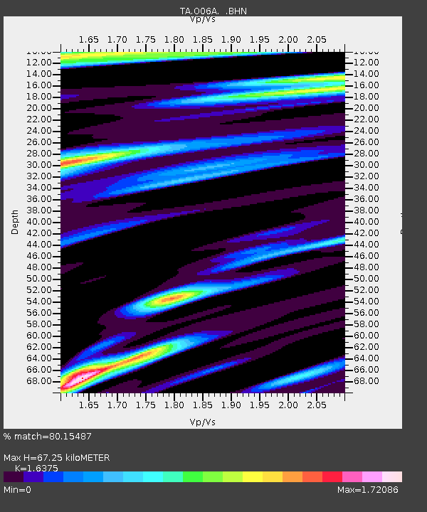
| Estimated Moho Depth: |
67.25 km |
| Estimated Crust Vp/Vs: |
1.64 |
| Assumed Crust Vp: |
6.276 km/s |
| Estimated Crust Vs: |
3.833 km/s |
| Estimated Crust Poisson's Ratio: |
0.20 |
|
| Radial Match: |
80.15487 % |
| Radial Bump: |
400 |
| Transverse Match: |
67.24186 % |
| Transverse Bump: |
400 |
| SOD ConfigId: |
2665 |
| Insert Time: |
2010-03-07 01:14:55.178 +0000 |
| GWidth: |
2.5 |
| Max Bumps: |
400 |
| Tol: |
0.001 |
|
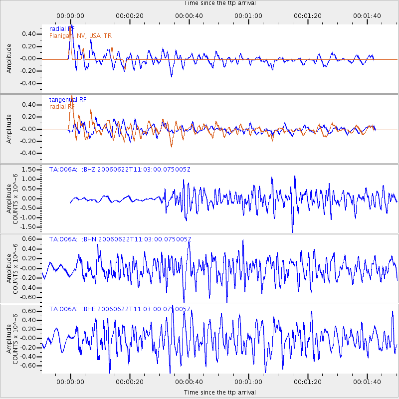
Signal To Noise
| Channel | StoN | STA | LTA |
| TA:O06A: :BHN:20060622T11:03:00.075005Z | 1.5530583 | 1.4730858E-7 | 9.485064E-8 |
| TA:O06A: :BHE:20060622T11:03:00.075005Z | 1.7281597 | 1.5206358E-7 | 8.799162E-8 |
| TA:O06A: :BHZ:20060622T11:03:00.075005Z | 2.8381019 | 2.4966798E-7 | 8.797006E-8 |
| Arrivals |
| Ps | 7.1 SECOND |
| PpPs | 27 SECOND |
| PsPs/PpSs | 34 SECOND |


