You are here: Home > Network List > TA - USArray Transportable Network (new EarthScope stations) Stations List
> Station O06A Flanigan, NV, USA > Earthquake Result Viewer
O06A Flanigan, NV, USA - Earthquake Result Viewer
| Earthquake location: |
Fiji Islands Region |
| Earthquake latitude/longitude: |
-16.5/177.0 |
| Earthquake time(UTC): |
2006/04/07 (097) 08:30:45 GMT |
| Earthquake Depth: |
22 km |
| Earthquake Magnitude: |
5.9 MB, 6.4 MS, 6.4 MW, 6.4 MW |
| Earthquake Catalog/Contributor: |
WHDF/NEIC |
|
| Network: |
TA USArray Transportable Network (new EarthScope stations) |
| Station: |
O06A Flanigan, NV, USA |
| Lat/Lon: |
40.17 N/119.83 W |
| Elevation: |
1229 m |
|
| Distance: |
81.4 deg |
| Az: |
43.769 deg |
| Baz: |
239.977 deg |
| Ray Param: |
0.047599312 |
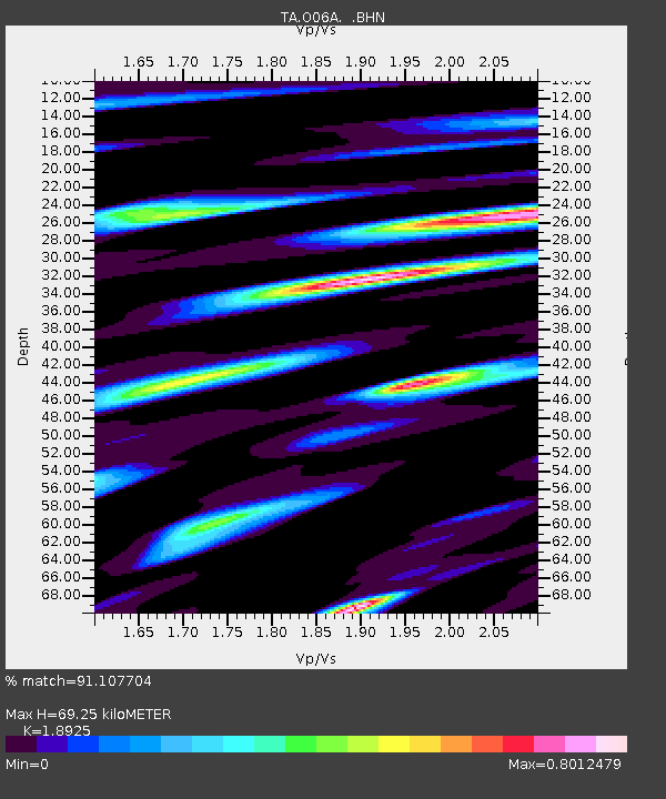
| Estimated Moho Depth: |
69.25 km |
| Estimated Crust Vp/Vs: |
1.89 |
| Assumed Crust Vp: |
6.276 km/s |
| Estimated Crust Vs: |
3.316 km/s |
| Estimated Crust Poisson's Ratio: |
0.31 |
|
| Radial Match: |
91.107704 % |
| Radial Bump: |
400 |
| Transverse Match: |
76.900894 % |
| Transverse Bump: |
400 |
| SOD ConfigId: |
2669 |
| Insert Time: |
2010-03-07 01:15:23.017 +0000 |
| GWidth: |
2.5 |
| Max Bumps: |
400 |
| Tol: |
0.001 |
|
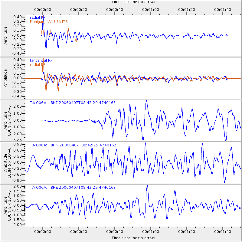
Signal To Noise
| Channel | StoN | STA | LTA |
| TA:O06A: :BHN:20060407T08:42:29.474016Z | 0.6749913 | 1.4540822E-7 | 2.1542238E-7 |
| TA:O06A: :BHE:20060407T08:42:29.474016Z | 2.7029612 | 2.034216E-7 | 7.52588E-8 |
| TA:O06A: :BHZ:20060407T08:42:29.474016Z | 5.405514 | 4.0245615E-7 | 7.445289E-8 |
| Arrivals |
| Ps | 10 SECOND |
| PpPs | 31 SECOND |
| PsPs/PpSs | 41 SECOND |


