You are here: Home > Network List > TA - USArray Transportable Network (new EarthScope stations) Stations List
> Station J06A Christmas Valley, OR, USA > Earthquake Result Viewer
J06A Christmas Valley, OR, USA - Earthquake Result Viewer
| Earthquake location: |
Near West Coast Of Colombia |
| Earthquake latitude/longitude: |
3.0/-78.0 |
| Earthquake time(UTC): |
2007/09/10 (253) 01:49:14 GMT |
| Earthquake Depth: |
31 km |
| Earthquake Magnitude: |
6.1 MB, 6.7 MS, 6.8 MW |
| Earthquake Catalog/Contributor: |
WHDF/NEIC |
|
| Network: |
TA USArray Transportable Network (new EarthScope stations) |
| Station: |
J06A Christmas Valley, OR, USA |
| Lat/Lon: |
43.25 N/120.15 W |
| Elevation: |
1407 m |
|
| Distance: |
54.8 deg |
| Az: |
323.116 deg |
| Baz: |
124.879 deg |
| Ray Param: |
0.065139085 |
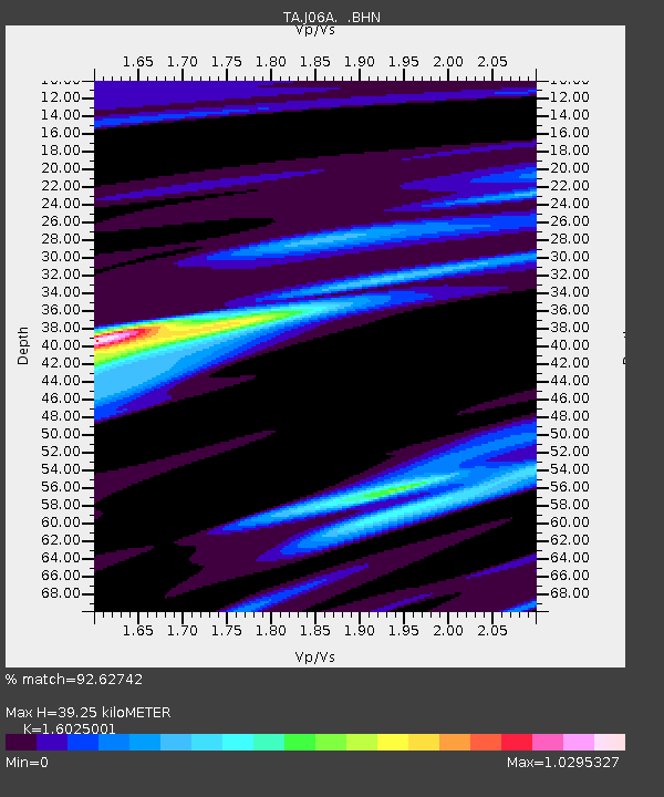
| Estimated Moho Depth: |
39.25 km |
| Estimated Crust Vp/Vs: |
1.60 |
| Assumed Crust Vp: |
6.597 km/s |
| Estimated Crust Vs: |
4.117 km/s |
| Estimated Crust Poisson's Ratio: |
0.18 |
|
| Radial Match: |
92.62742 % |
| Radial Bump: |
400 |
| Transverse Match: |
66.54202 % |
| Transverse Bump: |
400 |
| SOD ConfigId: |
2564 |
| Insert Time: |
2010-03-07 01:15:47.465 +0000 |
| GWidth: |
2.5 |
| Max Bumps: |
400 |
| Tol: |
0.001 |
|
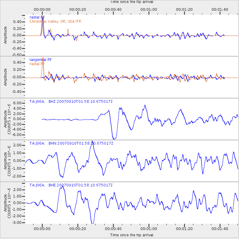
Signal To Noise
| Channel | StoN | STA | LTA |
| TA:J06A: :BHN:20070910T01:58:10.675017Z | 2.8968027 | 4.6046114E-7 | 1.5895496E-7 |
| TA:J06A: :BHE:20070910T01:58:10.675017Z | 5.364234 | 4.953007E-7 | 9.2333906E-8 |
| TA:J06A: :BHZ:20070910T01:58:10.675017Z | 11.883698 | 1.3568864E-6 | 1.1418048E-7 |
| Arrivals |
| Ps | 3.8 SECOND |
| PpPs | 15 SECOND |
| PsPs/PpSs | 18 SECOND |


