You are here: Home > Network List > TA - USArray Transportable Network (new EarthScope stations) Stations List
> Station J06A Christmas Valley, OR, USA > Earthquake Result Viewer
J06A Christmas Valley, OR, USA - Earthquake Result Viewer
| Earthquake location: |
Sea Of Japan |
| Earthquake latitude/longitude: |
36.8/134.9 |
| Earthquake time(UTC): |
2007/07/16 (197) 14:17:37 GMT |
| Earthquake Depth: |
350 km |
| Earthquake Magnitude: |
6.2 MB, 6.8 MW, 6.8 MW |
| Earthquake Catalog/Contributor: |
WHDF/NEIC |
|
| Network: |
TA USArray Transportable Network (new EarthScope stations) |
| Station: |
J06A Christmas Valley, OR, USA |
| Lat/Lon: |
43.25 N/120.15 W |
| Elevation: |
1407 m |
|
| Distance: |
75.2 deg |
| Az: |
46.886 deg |
| Baz: |
306.692 deg |
| Ray Param: |
0.050826464 |
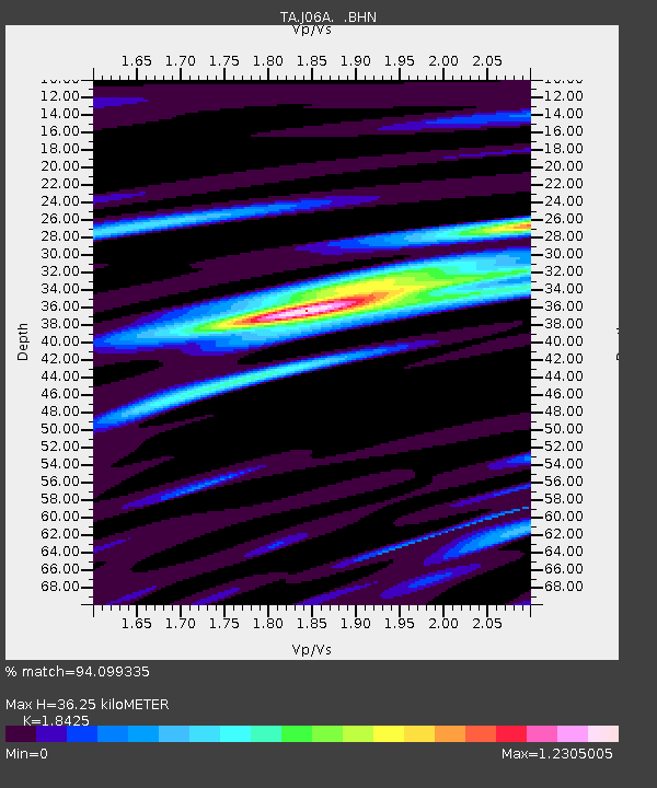
| Estimated Moho Depth: |
36.25 km |
| Estimated Crust Vp/Vs: |
1.84 |
| Assumed Crust Vp: |
6.597 km/s |
| Estimated Crust Vs: |
3.581 km/s |
| Estimated Crust Poisson's Ratio: |
0.29 |
|
| Radial Match: |
94.099335 % |
| Radial Bump: |
400 |
| Transverse Match: |
76.68542 % |
| Transverse Bump: |
400 |
| SOD ConfigId: |
2564 |
| Insert Time: |
2010-03-07 01:16:13.316 +0000 |
| GWidth: |
2.5 |
| Max Bumps: |
400 |
| Tol: |
0.001 |
|
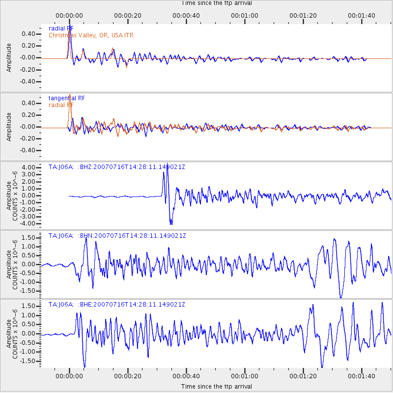
Signal To Noise
| Channel | StoN | STA | LTA |
| TA:J06A: :BHN:20070716T14:28:11.149021Z | 6.9493947 | 3.6326145E-7 | 5.2272387E-8 |
| TA:J06A: :BHE:20070716T14:28:11.149021Z | 13.391325 | 5.708025E-7 | 4.2624798E-8 |
| TA:J06A: :BHZ:20070716T14:28:11.149021Z | 37.030846 | 1.9672373E-6 | 5.312429E-8 |
| Arrivals |
| Ps | 4.8 SECOND |
| PpPs | 15 SECOND |
| PsPs/PpSs | 20 SECOND |


