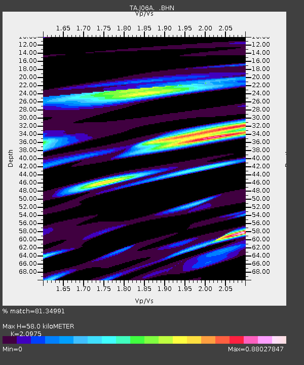
J06A Christmas Valley, OR, USA - Earthquake Result Viewer
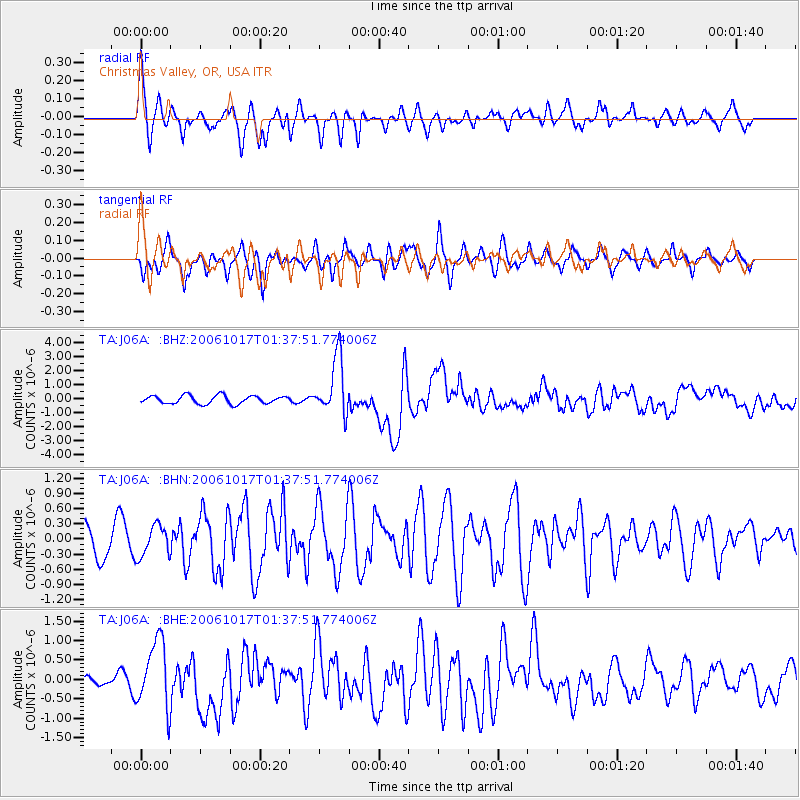
Earthquake location: New Britain Region, P.N.G.
Earthquake latitude/longitude: -5.9/151.0
Earthquake time(UTC): 2006/10/17 (290) 01:25:12 GMT
Earthquake Depth: 32 km
Earthquake Magnitude: 6.4 MB, 6.9 MS, 6.7 MW, 6.6 MW
Earthquake Catalog/Contributor: WHDF/NEIC
Network: TA USArray Transportable Network (new EarthScope stations)
Station: J06A Christmas Valley, OR, USA
Lat/Lon: 43.25 N/120.15 W
Elevation: 1407 m
Distance: 93.2 deg
Az: 47.022 deg
Baz: 264.954 deg
Ray Param: 0.041305583
Estimated Moho Depth: 58.0 km
Estimated Crust Vp/Vs: 2.10
Assumed Crust Vp: 6.597 km/s
Estimated Crust Vs: 3.145 km/s
Estimated Crust Poisson's Ratio: 0.35
Radial Match: 81.34991 %
Radial Bump: 400
Transverse Match: 74.67467 %
Transverse Bump: 400
SOD ConfigId: 2665
Insert Time: 2010-03-07 01:16:37.373 +0000
GWidth: 2.5
Max Bumps: 400
Tol: 0.001

Signal To Noise

ChannelStoNSTALTA
TA:J06A: :BHN:20061017T01:37:51.774006Z0.7975233.0509904E-73.825583E-7
TA:J06A: :BHE:20061017T01:37:51.774006Z2.38132728.680896E-73.6454023E-7
TA:J06A: :BHZ:20061017T01:37:51.774006Z7.09262132.0392827E-62.8752171E-7
Arrivals
Ps9.8 SECOND
PpPs27 SECOND
PsPs/PpSs37 SECOND