You are here: Home > Network List > TA - USArray Transportable Network (new EarthScope stations) Stations List
> Station J06A Christmas Valley, OR, USA > Earthquake Result Viewer
J06A Christmas Valley, OR, USA - Earthquake Result Viewer
| Earthquake location: |
Fox Islands, Aleutian Islands |
| Earthquake latitude/longitude: |
54.0/-166.4 |
| Earthquake time(UTC): |
2006/09/01 (244) 12:04:22 GMT |
| Earthquake Depth: |
76 km |
| Earthquake Magnitude: |
5.8 MB, 5.9 MW |
| Earthquake Catalog/Contributor: |
WHDF/NEIC |
|
| Network: |
TA USArray Transportable Network (new EarthScope stations) |
| Station: |
J06A Christmas Valley, OR, USA |
| Lat/Lon: |
43.25 N/120.15 W |
| Elevation: |
1407 m |
|
| Distance: |
31.9 deg |
| Az: |
90.473 deg |
| Baz: |
306.044 deg |
| Ray Param: |
0.07871705 |
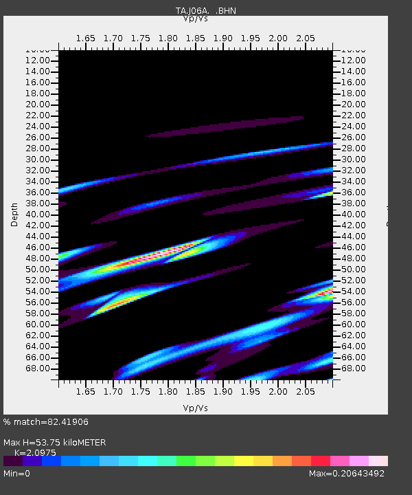
| Estimated Moho Depth: |
53.75 km |
| Estimated Crust Vp/Vs: |
2.10 |
| Assumed Crust Vp: |
6.597 km/s |
| Estimated Crust Vs: |
3.145 km/s |
| Estimated Crust Poisson's Ratio: |
0.35 |
|
| Radial Match: |
82.41906 % |
| Radial Bump: |
400 |
| Transverse Match: |
61.56953 % |
| Transverse Bump: |
400 |
| SOD ConfigId: |
2665 |
| Insert Time: |
2010-03-07 01:16:41.141 +0000 |
| GWidth: |
2.5 |
| Max Bumps: |
400 |
| Tol: |
0.001 |
|
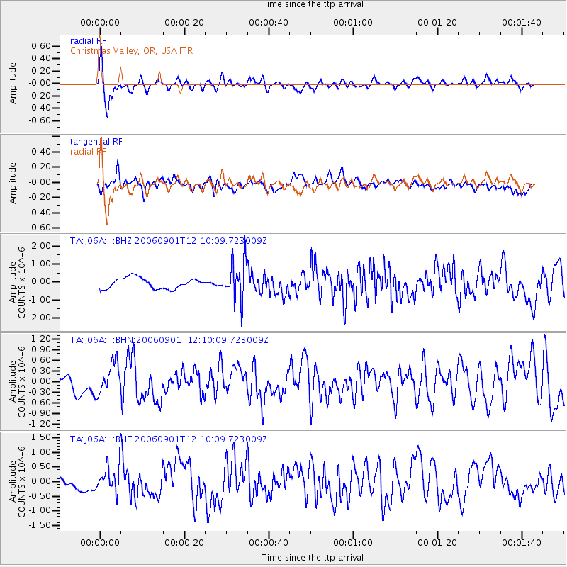
Signal To Noise
| Channel | StoN | STA | LTA |
| TA:J06A: :BHN:20060901T12:10:09.723009Z | 1.7507114 | 4.275309E-7 | 2.442041E-7 |
| TA:J06A: :BHE:20060901T12:10:09.723009Z | 1.8020521 | 4.6047535E-7 | 2.5552833E-7 |
| TA:J06A: :BHZ:20060901T12:10:09.723009Z | 3.804235 | 1.1290813E-6 | 2.9679586E-7 |
| Arrivals |
| Ps | 9.6 SECOND |
| PpPs | 24 SECOND |
| PsPs/PpSs | 33 SECOND |


