You are here: Home > Network List > TA - USArray Transportable Network (new EarthScope stations) Stations List
> Station J06A Christmas Valley, OR, USA > Earthquake Result Viewer
J06A Christmas Valley, OR, USA - Earthquake Result Viewer
| Earthquake location: |
Vanuatu Islands |
| Earthquake latitude/longitude: |
-15.8/167.8 |
| Earthquake time(UTC): |
2006/08/07 (219) 22:18:54 GMT |
| Earthquake Depth: |
141 km |
| Earthquake Magnitude: |
6.0 MB, 6.8 MW, 6.8 MW |
| Earthquake Catalog/Contributor: |
WHDF/NEIC |
|
| Network: |
TA USArray Transportable Network (new EarthScope stations) |
| Station: |
J06A Christmas Valley, OR, USA |
| Lat/Lon: |
43.25 N/120.15 W |
| Elevation: |
1407 m |
|
| Distance: |
88.1 deg |
| Az: |
44.062 deg |
| Baz: |
246.407 deg |
| Ray Param: |
0.042491935 |
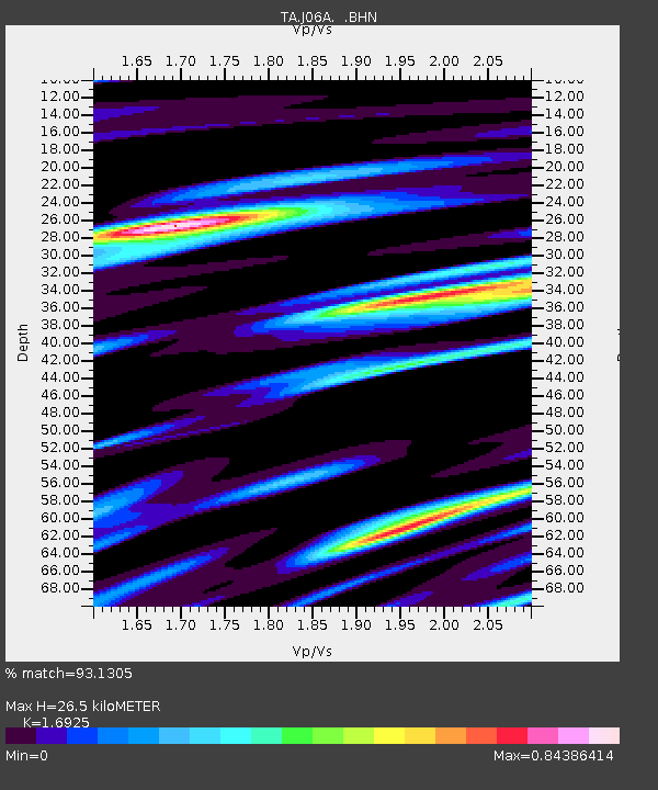
| Estimated Moho Depth: |
26.5 km |
| Estimated Crust Vp/Vs: |
1.69 |
| Assumed Crust Vp: |
6.597 km/s |
| Estimated Crust Vs: |
3.898 km/s |
| Estimated Crust Poisson's Ratio: |
0.23 |
|
| Radial Match: |
93.1305 % |
| Radial Bump: |
400 |
| Transverse Match: |
79.38014 % |
| Transverse Bump: |
400 |
| SOD ConfigId: |
2665 |
| Insert Time: |
2010-03-07 01:16:48.278 +0000 |
| GWidth: |
2.5 |
| Max Bumps: |
400 |
| Tol: |
0.001 |
|

Signal To Noise
| Channel | StoN | STA | LTA |
| TA:J06A: :BHN:20060807T22:30:57.725017Z | 1.8327811 | 1.4784094E-7 | 8.066481E-8 |
| TA:J06A: :BHE:20060807T22:30:57.725017Z | 4.874705 | 5.1196247E-7 | 1.0502429E-7 |
| TA:J06A: :BHZ:20060807T22:30:57.725017Z | 16.053005 | 1.3981817E-6 | 8.709782E-8 |
| Arrivals |
| Ps | 2.8 SECOND |
| PpPs | 11 SECOND |
| PsPs/PpSs | 13 SECOND |


