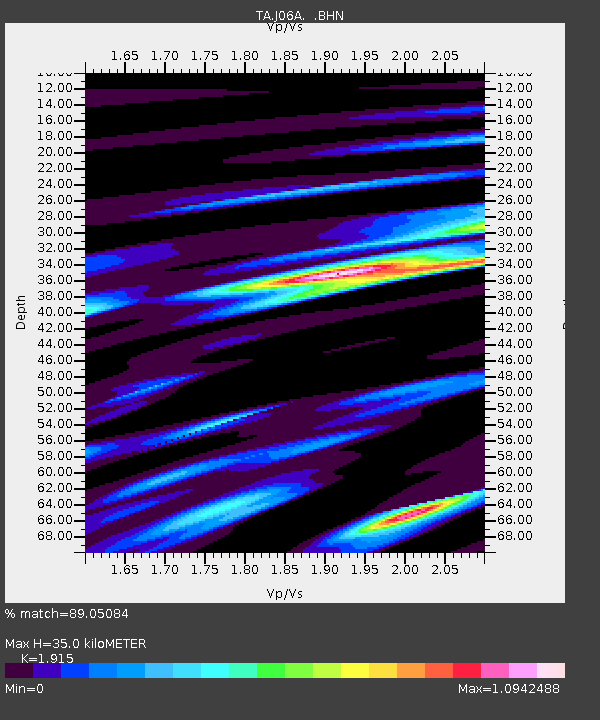
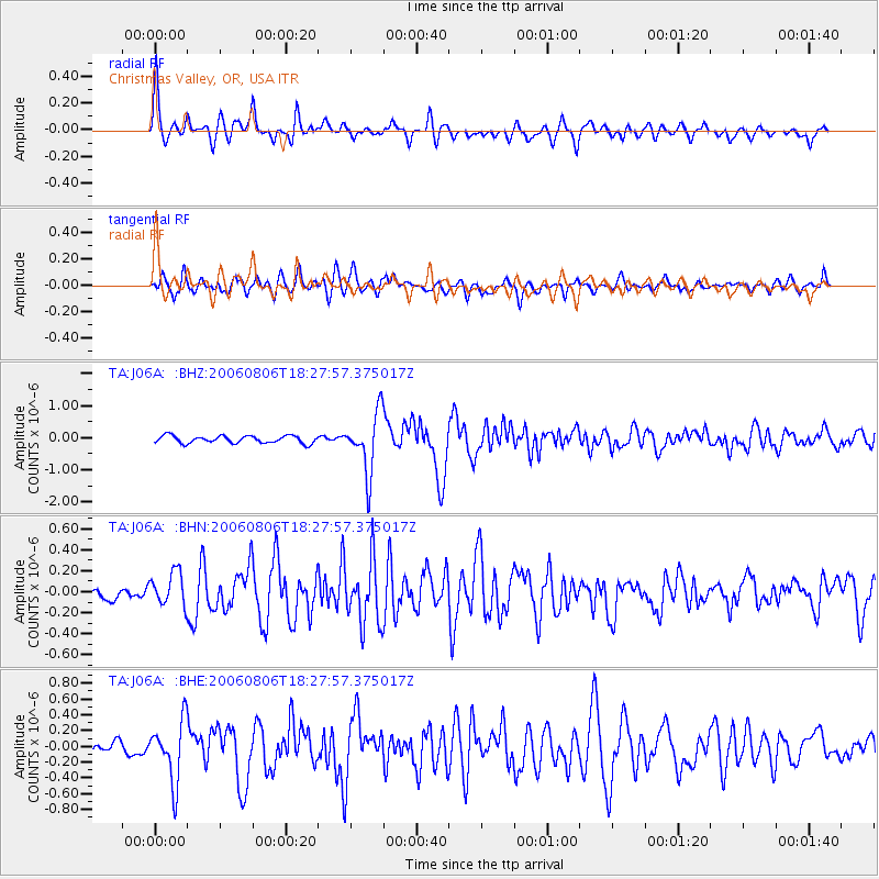
J06A Christmas Valley, OR, USA - Earthquake Result Viewer

Earthquake location: Bonin Islands, Japan Region
Earthquake latitude/longitude: 26.1/144.0
Earthquake time(UTC): 2006/08/06 (218) 18:16:40 GMT
Earthquake Depth: 23 km
Earthquake Magnitude: 6.0 MB, 5.6 MS, 5.8 MW, 5.8 MW
Earthquake Catalog/Contributor: WHDF/NEIC
Network: TA USArray Transportable Network (new EarthScope stations)
Station: J06A Christmas Valley, OR, USA
Lat/Lon: 43.25 N/120.15 W
Elevation: 1407 m
Distance: 76.6 deg
Az: 48.354 deg
Baz: 293.149 deg
Ray Param: 0.050875247
Estimated Moho Depth: 35.0 km
Estimated Crust Vp/Vs: 1.91
Assumed Crust Vp: 6.597 km/s
Estimated Crust Vs: 3.445 km/s
Estimated Crust Poisson's Ratio: 0.31
Radial Match: 89.05084 %
Radial Bump: 400
Transverse Match: 77.04367 %
Transverse Bump: 400
SOD ConfigId: 2665
Insert Time: 2010-03-07 01:16:49.663 +0000
GWidth: 2.5
Max Bumps: 400
Tol: 0.001

Signal To Noise

ChannelStoNSTALTA
TA:J06A: :BHN:20060806T18:27:57.375017Z2.46260071.590406E-76.458238E-8
TA:J06A: :BHE:20060806T18:27:57.375017Z4.3467363.799624E-78.741327E-8
TA:J06A: :BHZ:20060806T18:27:57.375017Z8.0409659.2501796E-71.1503817E-7
Arrivals
Ps5.0 SECOND
PpPs15 SECOND
PsPs/PpSs20 SECOND