You are here: Home > Network List > TA - USArray Transportable Network (new EarthScope stations) Stations List
> Station J06A Christmas Valley, OR, USA > Earthquake Result Viewer
J06A Christmas Valley, OR, USA - Earthquake Result Viewer
| Earthquake location: |
Tonga Islands |
| Earthquake latitude/longitude: |
-15.2/-173.6 |
| Earthquake time(UTC): |
2006/07/07 (188) 07:26:12 GMT |
| Earthquake Depth: |
35 km |
| Earthquake Magnitude: |
5.7 MB, 5.9 MS, 6.0 MW, 6.0 MW |
| Earthquake Catalog/Contributor: |
WHDF/NEIC |
|
| Network: |
TA USArray Transportable Network (new EarthScope stations) |
| Station: |
J06A Christmas Valley, OR, USA |
| Lat/Lon: |
43.25 N/120.15 W |
| Elevation: |
1407 m |
|
| Distance: |
76.0 deg |
| Az: |
37.223 deg |
| Baz: |
233.05 deg |
| Ray Param: |
0.051222213 |
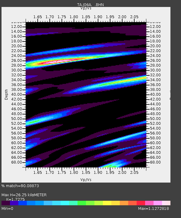
| Estimated Moho Depth: |
26.25 km |
| Estimated Crust Vp/Vs: |
1.73 |
| Assumed Crust Vp: |
6.597 km/s |
| Estimated Crust Vs: |
3.819 km/s |
| Estimated Crust Poisson's Ratio: |
0.25 |
|
| Radial Match: |
90.08873 % |
| Radial Bump: |
400 |
| Transverse Match: |
86.589836 % |
| Transverse Bump: |
400 |
| SOD ConfigId: |
2665 |
| Insert Time: |
2010-03-07 01:16:54.128 +0000 |
| GWidth: |
2.5 |
| Max Bumps: |
400 |
| Tol: |
0.001 |
|
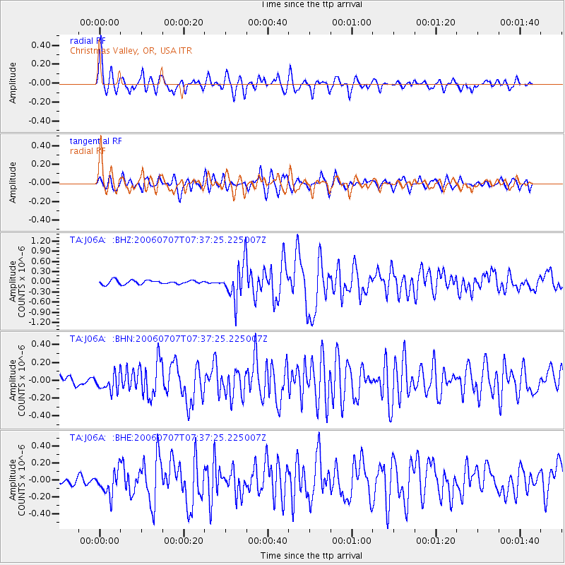
Signal To Noise
| Channel | StoN | STA | LTA |
| TA:J06A: :BHN:20060707T07:37:25.225007Z | 2.4352627 | 9.748027E-8 | 4.0028645E-8 |
| TA:J06A: :BHE:20060707T07:37:25.225007Z | 3.2295344 | 1.445069E-7 | 4.474543E-8 |
| TA:J06A: :BHZ:20060707T07:37:25.225007Z | 9.722639 | 5.4974447E-7 | 5.654272E-8 |
| Arrivals |
| Ps | 3.0 SECOND |
| PpPs | 10 SECOND |
| PsPs/PpSs | 13 SECOND |


