You are here: Home > Network List > TA - USArray Transportable Network (new EarthScope stations) Stations List
> Station N15K Kwethluk River, AK, USA > Earthquake Result Viewer
N15K Kwethluk River, AK, USA - Earthquake Result Viewer
| Earthquake location: |
Vanuatu Islands |
| Earthquake latitude/longitude: |
-21.0/169.8 |
| Earthquake time(UTC): |
2019/07/06 (187) 11:08:16 GMT |
| Earthquake Depth: |
99 km |
| Earthquake Magnitude: |
5.6 Mww |
| Earthquake Catalog/Contributor: |
NEIC PDE/us |
|
| Network: |
TA USArray Transportable Network (new EarthScope stations) |
| Station: |
N15K Kwethluk River, AK, USA |
| Lat/Lon: |
60.17 N/160.09 W |
| Elevation: |
449 m |
|
| Distance: |
84.5 deg |
| Az: |
14.59 deg |
| Baz: |
208.089 deg |
| Ray Param: |
0.0452304 |
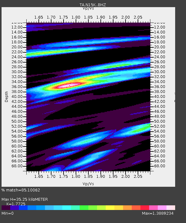
| Estimated Moho Depth: |
35.25 km |
| Estimated Crust Vp/Vs: |
1.77 |
| Assumed Crust Vp: |
6.182 km/s |
| Estimated Crust Vs: |
3.488 km/s |
| Estimated Crust Poisson's Ratio: |
0.27 |
|
| Radial Match: |
85.10062 % |
| Radial Bump: |
400 |
| Transverse Match: |
73.038376 % |
| Transverse Bump: |
400 |
| SOD ConfigId: |
19053131 |
| Insert Time: |
2019-07-20 11:15:27.475 +0000 |
| GWidth: |
2.5 |
| Max Bumps: |
400 |
| Tol: |
0.001 |
|

Signal To Noise
| Channel | StoN | STA | LTA |
| TA:N15K: :BHZ:20190706T11:20:07.275021Z | 13.075125 | 9.706099E-7 | 7.423332E-8 |
| TA:N15K: :BHN:20190706T11:20:07.275021Z | 4.512774 | 3.065451E-7 | 6.7928305E-8 |
| TA:N15K: :BHE:20190706T11:20:07.275021Z | 3.4240108 | 2.7113154E-7 | 7.918537E-8 |
| Arrivals |
| Ps | 4.5 SECOND |
| PpPs | 15 SECOND |
| PsPs/PpSs | 20 SECOND |


