You are here: Home > Network List > TA - USArray Transportable Network (new EarthScope stations) Stations List
> Station N16K Nishlik Lake, AK, USA > Earthquake Result Viewer
N16K Nishlik Lake, AK, USA - Earthquake Result Viewer
| Earthquake location: |
Vanuatu Islands |
| Earthquake latitude/longitude: |
-21.0/169.8 |
| Earthquake time(UTC): |
2019/07/06 (187) 11:08:16 GMT |
| Earthquake Depth: |
99 km |
| Earthquake Magnitude: |
5.6 Mww |
| Earthquake Catalog/Contributor: |
NEIC PDE/us |
|
| Network: |
TA USArray Transportable Network (new EarthScope stations) |
| Station: |
N16K Nishlik Lake, AK, USA |
| Lat/Lon: |
60.47 N/158.77 W |
| Elevation: |
582 m |
|
| Distance: |
85.1 deg |
| Az: |
15.022 deg |
| Baz: |
209.276 deg |
| Ray Param: |
0.044812027 |
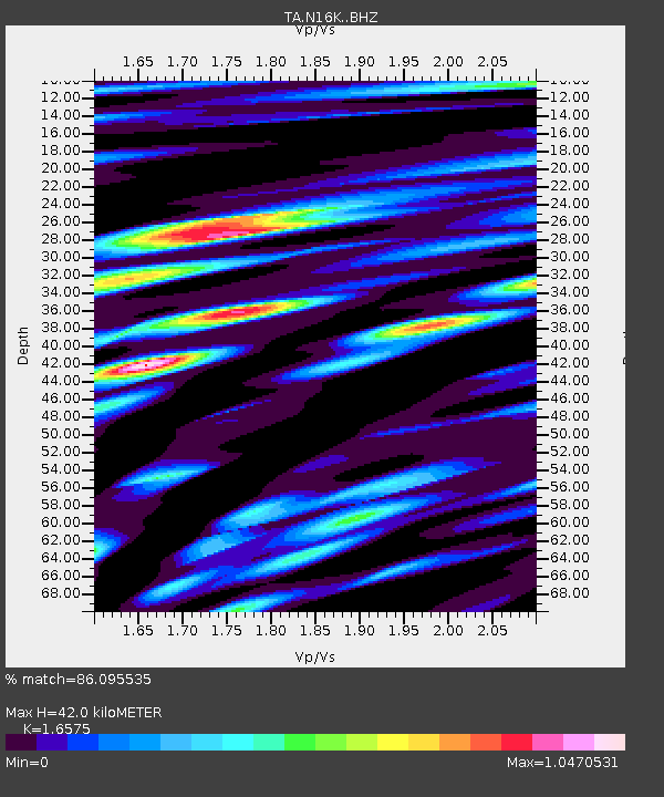
| Estimated Moho Depth: |
42.0 km |
| Estimated Crust Vp/Vs: |
1.66 |
| Assumed Crust Vp: |
6.276 km/s |
| Estimated Crust Vs: |
3.786 km/s |
| Estimated Crust Poisson's Ratio: |
0.21 |
|
| Radial Match: |
86.095535 % |
| Radial Bump: |
400 |
| Transverse Match: |
79.06714 % |
| Transverse Bump: |
400 |
| SOD ConfigId: |
19053131 |
| Insert Time: |
2019-07-20 11:15:28.541 +0000 |
| GWidth: |
2.5 |
| Max Bumps: |
400 |
| Tol: |
0.001 |
|

Signal To Noise
| Channel | StoN | STA | LTA |
| TA:N16K: :BHZ:20190706T11:20:10.200008Z | 16.227268 | 9.323918E-7 | 5.745833E-8 |
| TA:N16K: :BHN:20190706T11:20:10.200008Z | 6.749439 | 3.141078E-7 | 4.653836E-8 |
| TA:N16K: :BHE:20190706T11:20:10.200008Z | 3.8190544 | 2.8109966E-7 | 7.360452E-8 |
| Arrivals |
| Ps | 4.5 SECOND |
| PpPs | 17 SECOND |
| PsPs/PpSs | 22 SECOND |


