You are here: Home > Network List > TA - USArray Transportable Network (new EarthScope stations) Stations List
> Station M09A Marrel Ranch, Paradise Valley, NV, USA > Earthquake Result Viewer
M09A Marrel Ranch, Paradise Valley, NV, USA - Earthquake Result Viewer

| Earthquake location: |
Peru-Ecuador Border Region |
| Earthquake latitude/longitude: |
-2.3/-77.8 |
| Earthquake time(UTC): |
2007/11/16 (320) 03:13:00 GMT |
| Earthquake Depth: |
123 km |
| Earthquake Magnitude: |
6.3 MB, 6.8 MW, 6.7 MW |
| Earthquake Catalog/Contributor: |
WHDF/NEIC |
|
| Network: |
TA USArray Transportable Network (new EarthScope stations) |
| Station: |
M09A Marrel Ranch, Paradise Valley, NV, USA |
| Lat/Lon: |
41.42 N/117.45 W |
| Elevation: |
1356 m |
|
| Distance: |
56.5 deg |
| Az: |
324.882 deg |
| Baz: |
130.154 deg |
| Ray Param: |
0.06374274 |
| Estimated Moho Depth: |
46.75 km |
| Estimated Crust Vp/Vs: |
2.10 |
| Assumed Crust Vp: |
6.276 km/s |
| Estimated Crust Vs: |
2.992 km/s |
| Estimated Crust Poisson's Ratio: |
0.35 |
|
| Radial Match: |
85.400856 % |
| Radial Bump: |
400 |
| Transverse Match: |
81.79005 % |
| Transverse Bump: |
400 |
| SOD ConfigId: |
2564 |
| Insert Time: |
2010-03-07 01:17:25.122 +0000 |
| GWidth: |
2.5 |
| Max Bumps: |
400 |
| Tol: |
0.001 |
|
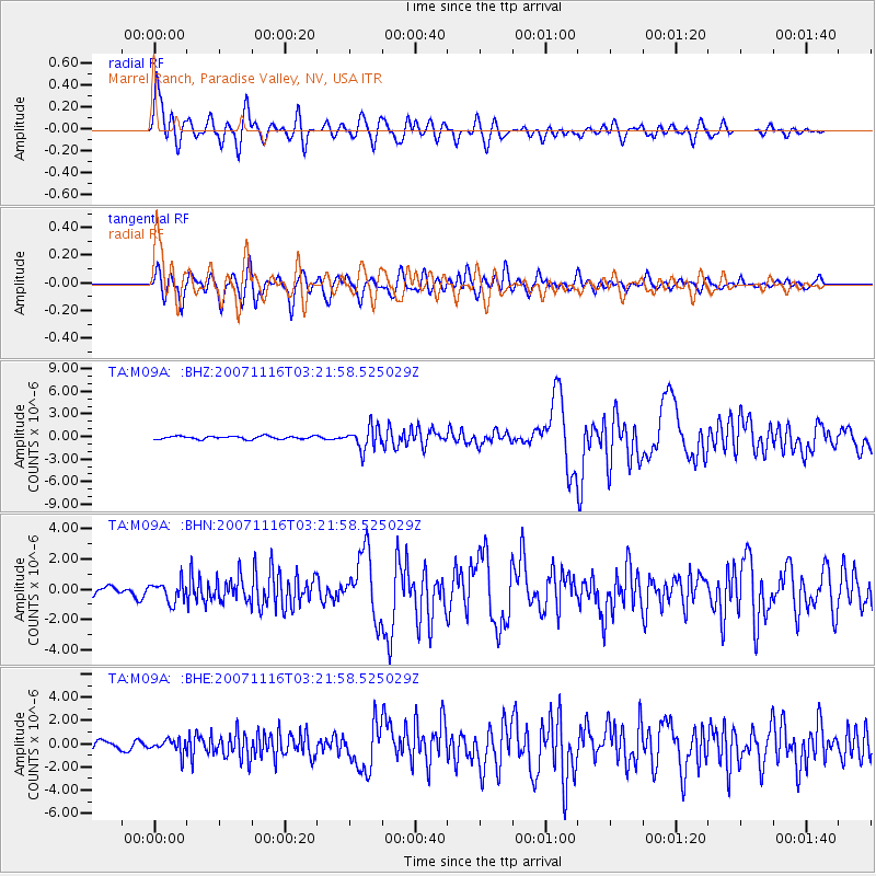
Signal To Noise
| Channel | StoN | STA | LTA |
| TA:M09A: :BHN:20071116T03:21:58.525029Z | 1.7269039 | 6.594312E-7 | 3.818575E-7 |
| TA:M09A: :BHE:20071116T03:21:58.525029Z | 1.2942544 | 5.9453157E-7 | 4.593622E-7 |
| TA:M09A: :BHZ:20071116T03:21:58.525029Z | 7.2426047 | 1.4928503E-6 | 2.0612063E-7 |
| Arrivals |
| Ps | 8.5 SECOND |
| PpPs | 22 SECOND |
| PsPs/PpSs | 31 SECOND |


