You are here: Home > Network List > TA - USArray Transportable Network (new EarthScope stations) Stations List
> Station Q16K King Salmon, AK, USA > Earthquake Result Viewer
Q16K King Salmon, AK, USA - Earthquake Result Viewer
| Earthquake location: |
Vanuatu Islands |
| Earthquake latitude/longitude: |
-21.0/169.8 |
| Earthquake time(UTC): |
2019/07/06 (187) 11:08:16 GMT |
| Earthquake Depth: |
99 km |
| Earthquake Magnitude: |
5.6 Mww |
| Earthquake Catalog/Contributor: |
NEIC PDE/us |
|
| Network: |
TA USArray Transportable Network (new EarthScope stations) |
| Station: |
Q16K King Salmon, AK, USA |
| Lat/Lon: |
58.68 N/156.66 W |
| Elevation: |
22 m |
|
| Distance: |
84.1 deg |
| Az: |
16.868 deg |
| Baz: |
211.27 deg |
| Ray Param: |
0.04553752 |
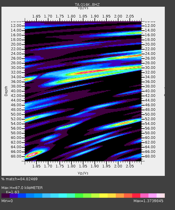
| Estimated Moho Depth: |
67.0 km |
| Estimated Crust Vp/Vs: |
1.63 |
| Assumed Crust Vp: |
6.276 km/s |
| Estimated Crust Vs: |
3.85 km/s |
| Estimated Crust Poisson's Ratio: |
0.20 |
|
| Radial Match: |
84.82469 % |
| Radial Bump: |
400 |
| Transverse Match: |
80.00149 % |
| Transverse Bump: |
400 |
| SOD ConfigId: |
19053131 |
| Insert Time: |
2019-07-20 11:15:45.415 +0000 |
| GWidth: |
2.5 |
| Max Bumps: |
400 |
| Tol: |
0.001 |
|

Signal To Noise
| Channel | StoN | STA | LTA |
| TA:Q16K: :BHZ:20190706T11:20:05.099972Z | 13.769602 | 1.3473693E-6 | 9.7851E-8 |
| TA:Q16K: :BHN:20190706T11:20:05.099972Z | 3.4791589 | 5.646521E-7 | 1.6229558E-7 |
| TA:Q16K: :BHE:20190706T11:20:05.099972Z | 3.6037087 | 5.232081E-7 | 1.4518601E-7 |
| Arrivals |
| Ps | 6.9 SECOND |
| PpPs | 27 SECOND |
| PsPs/PpSs | 34 SECOND |


