You are here: Home > Network List > TA - USArray Transportable Network (new EarthScope stations) Stations List
> Station Q17K Contact Creek, Katmai, AK, USA > Earthquake Result Viewer
Q17K Contact Creek, Katmai, AK, USA - Earthquake Result Viewer
| Earthquake location: |
Vanuatu Islands |
| Earthquake latitude/longitude: |
-21.0/169.8 |
| Earthquake time(UTC): |
2019/07/06 (187) 11:08:16 GMT |
| Earthquake Depth: |
99 km |
| Earthquake Magnitude: |
5.6 Mww |
| Earthquake Catalog/Contributor: |
NEIC PDE/us |
|
| Network: |
TA USArray Transportable Network (new EarthScope stations) |
| Station: |
Q17K Contact Creek, Katmai, AK, USA |
| Lat/Lon: |
58.26 N/155.89 W |
| Elevation: |
1165 m |
|
| Distance: |
83.9 deg |
| Az: |
17.433 deg |
| Baz: |
211.983 deg |
| Ray Param: |
0.04563591 |
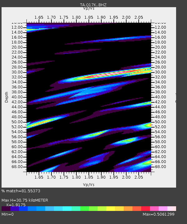
| Estimated Moho Depth: |
30.75 km |
| Estimated Crust Vp/Vs: |
1.92 |
| Assumed Crust Vp: |
6.438 km/s |
| Estimated Crust Vs: |
3.358 km/s |
| Estimated Crust Poisson's Ratio: |
0.31 |
|
| Radial Match: |
81.55373 % |
| Radial Bump: |
400 |
| Transverse Match: |
83.077065 % |
| Transverse Bump: |
400 |
| SOD ConfigId: |
19053131 |
| Insert Time: |
2019-07-20 11:15:45.643 +0000 |
| GWidth: |
2.5 |
| Max Bumps: |
400 |
| Tol: |
0.001 |
|

Signal To Noise
| Channel | StoN | STA | LTA |
| TA:Q17K: :BHZ:20190706T11:20:04.400021Z | 9.202038 | 1.0381792E-6 | 1.12820565E-7 |
| TA:Q17K: :BHN:20190706T11:20:04.400021Z | 4.043575 | 3.375675E-7 | 8.348245E-8 |
| TA:Q17K: :BHE:20190706T11:20:04.400021Z | 4.7831435 | 2.8977738E-7 | 6.0583034E-8 |
| Arrivals |
| Ps | 4.5 SECOND |
| PpPs | 14 SECOND |
| PsPs/PpSs | 18 SECOND |


