You are here: Home > Network List > TA - USArray Transportable Network (new EarthScope stations) Stations List
> Station M09A Marrel Ranch, Paradise Valley, NV, USA > Earthquake Result Viewer
M09A Marrel Ranch, Paradise Valley, NV, USA - Earthquake Result Viewer

| Earthquake location: |
Kuril Islands |
| Earthquake latitude/longitude: |
46.6/153.3 |
| Earthquake time(UTC): |
2006/11/15 (319) 11:14:13 GMT |
| Earthquake Depth: |
10 km |
| Earthquake Magnitude: |
6.5 MB, 7.8 MS, 8.3 MW, 7.9 MW |
| Earthquake Catalog/Contributor: |
WHDF/NEIC |
|
| Network: |
TA USArray Transportable Network (new EarthScope stations) |
| Station: |
M09A Marrel Ranch, Paradise Valley, NV, USA |
| Lat/Lon: |
41.42 N/117.45 W |
| Elevation: |
1356 m |
|
| Distance: |
61.1 deg |
| Az: |
59.23 deg |
| Baz: |
308.009 deg |
| Ray Param: |
0.06111657 |
| Estimated Moho Depth: |
38.5 km |
| Estimated Crust Vp/Vs: |
2.04 |
| Assumed Crust Vp: |
6.276 km/s |
| Estimated Crust Vs: |
3.08 km/s |
| Estimated Crust Poisson's Ratio: |
0.34 |
|
| Radial Match: |
95.841934 % |
| Radial Bump: |
400 |
| Transverse Match: |
82.163895 % |
| Transverse Bump: |
400 |
| SOD ConfigId: |
2564 |
| Insert Time: |
2010-03-07 01:18:14.115 +0000 |
| GWidth: |
2.5 |
| Max Bumps: |
400 |
| Tol: |
0.001 |
|
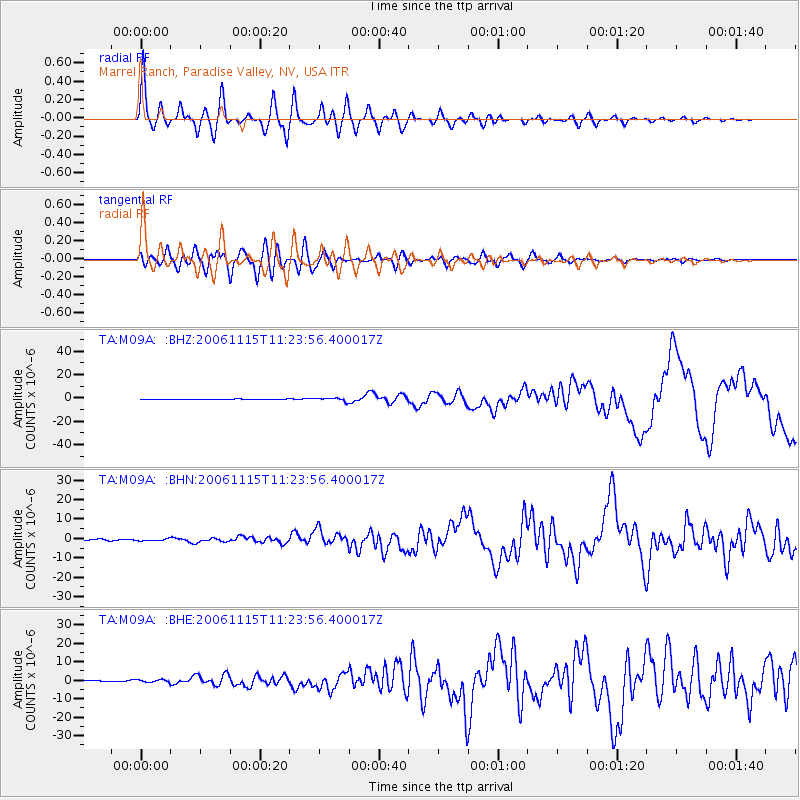
Signal To Noise
| Channel | StoN | STA | LTA |
| TA:M09A: :BHN:20061115T11:23:56.400017Z | 1.8031981 | 5.101536E-7 | 2.8291598E-7 |
| TA:M09A: :BHE:20061115T11:23:56.400017Z | 1.6959778 | 7.224624E-7 | 4.259858E-7 |
| TA:M09A: :BHZ:20061115T11:23:56.400017Z | 7.7077785 | 1.4020361E-6 | 1.8189886E-7 |
| Arrivals |
| Ps | 6.6 SECOND |
| PpPs | 18 SECOND |
| PsPs/PpSs | 25 SECOND |


