You are here: Home > Network List > BK - Berkeley Digital Seismograph Network Stations List
> Station HUMO Hull Mountain, OR > Earthquake Result Viewer
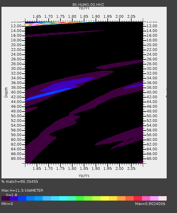
HUMO Hull Mountain, OR - Earthquake Result Viewer
| Earthquake location: |
Solomon Islands |
| Earthquake latitude/longitude: |
-11.0/161.3 |
| Earthquake time(UTC): |
2016/12/09 (344) 19:43:23 GMT |
| Earthquake Depth: |
18 km |
| Earthquake Magnitude: |
5.5 mb |
| Earthquake Catalog/Contributor: |
NEIC PDE/us |
|
| Network: |
BK Berkeley Digital Seismograph Network |
| Station: |
HUMO Hull Mountain, OR |
| Lat/Lon: |
42.61 N/122.96 W |
| Elevation: |
555 m |
|
| Distance: |
87.1 deg |
| Az: |
45.757 deg |
| Baz: |
252.339 deg |
| Ray Param: |
0.043589313 |
| Estimated Moho Depth: |
11.5 km |
| Estimated Crust Vp/Vs: |
1.60 |
| Assumed Crust Vp: |
6.522 km/s |
| Estimated Crust Vs: |
4.076 km/s |
| Estimated Crust Poisson's Ratio: |
0.18 |
|
| Radial Match: |
98.35455 % |
| Radial Bump: |
318 |
| Transverse Match: |
78.96203 % |
| Transverse Bump: |
400 |
| SOD ConfigId: |
1894071 |
| Insert Time: |
2016-12-23 19:43:47.034 +0000 |
| GWidth: |
2.5 |
| Max Bumps: |
400 |
| Tol: |
0.001 |
|

Signal To Noise
| Channel | StoN | STA | LTA |
| BK:HUMO:00:HHZ:20161209T19:55:36.778013Z | 1.057656 | 8.421026E-6 | 7.961971E-6 |
| BK:HUMO:00:HHN:20161209T19:55:36.778013Z | 3.5125704 | 1.6662422E-6 | 4.7436546E-7 |
| BK:HUMO:00:HHE:20161209T19:55:36.778013Z | 0.98392284 | 6.1518404E-6 | 6.2523604E-6 |
| Arrivals |
| Ps | 1.1 SECOND |
| PpPs | 4.5 SECOND |
| PsPs/PpSs | 5.6 SECOND |


