You are here: Home > Network List > TA - USArray Transportable Network (new EarthScope stations) Stations List
> Station M09A Marrel Ranch, Paradise Valley, NV, USA > Earthquake Result Viewer
M09A Marrel Ranch, Paradise Valley, NV, USA - Earthquake Result Viewer
| Earthquake location: |
Tonga Islands |
| Earthquake latitude/longitude: |
-15.2/-173.6 |
| Earthquake time(UTC): |
2006/07/07 (188) 07:26:12 GMT |
| Earthquake Depth: |
35 km |
| Earthquake Magnitude: |
5.7 MB, 5.9 MS, 6.0 MW, 6.0 MW |
| Earthquake Catalog/Contributor: |
WHDF/NEIC |
|
| Network: |
TA USArray Transportable Network (new EarthScope stations) |
| Station: |
M09A Marrel Ranch, Paradise Valley, NV, USA |
| Lat/Lon: |
41.42 N/117.45 W |
| Elevation: |
1356 m |
|
| Distance: |
76.6 deg |
| Az: |
39.954 deg |
| Baz: |
235.511 deg |
| Ray Param: |
0.050845586 |
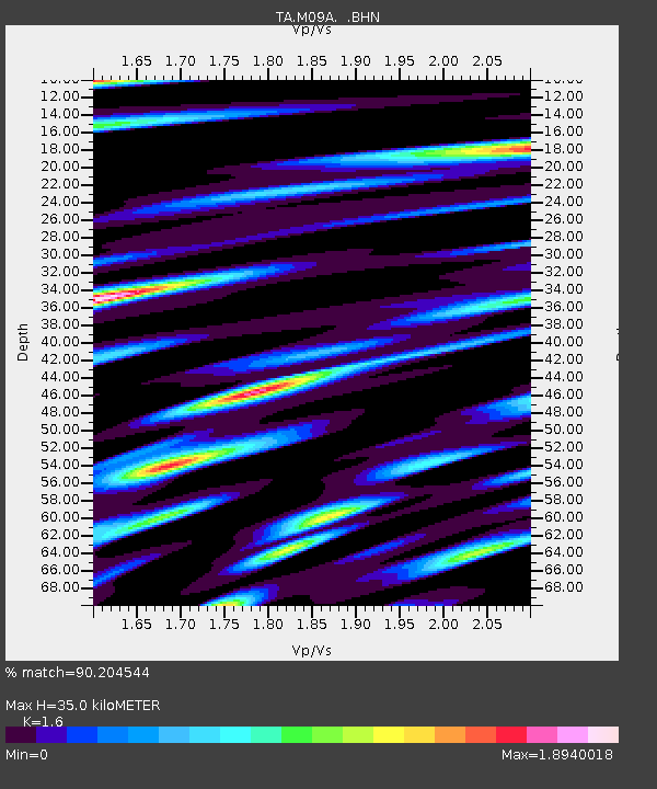
| Estimated Moho Depth: |
35.0 km |
| Estimated Crust Vp/Vs: |
1.60 |
| Assumed Crust Vp: |
6.276 km/s |
| Estimated Crust Vs: |
3.922 km/s |
| Estimated Crust Poisson's Ratio: |
0.18 |
|
| Radial Match: |
90.204544 % |
| Radial Bump: |
400 |
| Transverse Match: |
87.05509 % |
| Transverse Bump: |
400 |
| SOD ConfigId: |
2665 |
| Insert Time: |
2010-03-07 01:18:36.482 +0000 |
| GWidth: |
2.5 |
| Max Bumps: |
400 |
| Tol: |
0.001 |
|

Signal To Noise
| Channel | StoN | STA | LTA |
| TA:M09A: :BHN:20060707T07:37:28.399019Z | 2.8923056 | 2.0536905E-7 | 7.10053E-8 |
| TA:M09A: :BHE:20060707T07:37:28.399019Z | 3.4588265 | 3.8700287E-7 | 1.1188849E-7 |
| TA:M09A: :BHZ:20060707T07:37:28.399019Z | 21.239237 | 7.0092307E-7 | 3.3001328E-8 |
| Arrivals |
| Ps | 3.5 SECOND |
| PpPs | 14 SECOND |
| PsPs/PpSs | 17 SECOND |


