You are here: Home > Network List > TA - USArray Transportable Network (new EarthScope stations) Stations List
> Station M09A Marrel Ranch, Paradise Valley, NV, USA > Earthquake Result Viewer
M09A Marrel Ranch, Paradise Valley, NV, USA - Earthquake Result Viewer

| Earthquake location: |
Kuril Islands |
| Earthquake latitude/longitude: |
45.4/149.3 |
| Earthquake time(UTC): |
2006/06/22 (173) 10:53:11 GMT |
| Earthquake Depth: |
95 km |
| Earthquake Magnitude: |
6.1 MB, 6.0 MW, 5.9 MW |
| Earthquake Catalog/Contributor: |
WHDF/NEIC |
|
| Network: |
TA USArray Transportable Network (new EarthScope stations) |
| Station: |
M09A Marrel Ranch, Paradise Valley, NV, USA |
| Lat/Lon: |
41.42 N/117.45 W |
| Elevation: |
1356 m |
|
| Distance: |
64.0 deg |
| Az: |
56.653 deg |
| Baz: |
308.523 deg |
| Ray Param: |
0.058949698 |
| Estimated Moho Depth: |
32.75 km |
| Estimated Crust Vp/Vs: |
2.07 |
| Assumed Crust Vp: |
6.276 km/s |
| Estimated Crust Vs: |
3.028 km/s |
| Estimated Crust Poisson's Ratio: |
0.35 |
|
| Radial Match: |
85.24328 % |
| Radial Bump: |
400 |
| Transverse Match: |
80.24469 % |
| Transverse Bump: |
400 |
| SOD ConfigId: |
2665 |
| Insert Time: |
2010-03-07 01:18:39.129 +0000 |
| GWidth: |
2.5 |
| Max Bumps: |
400 |
| Tol: |
0.001 |
|
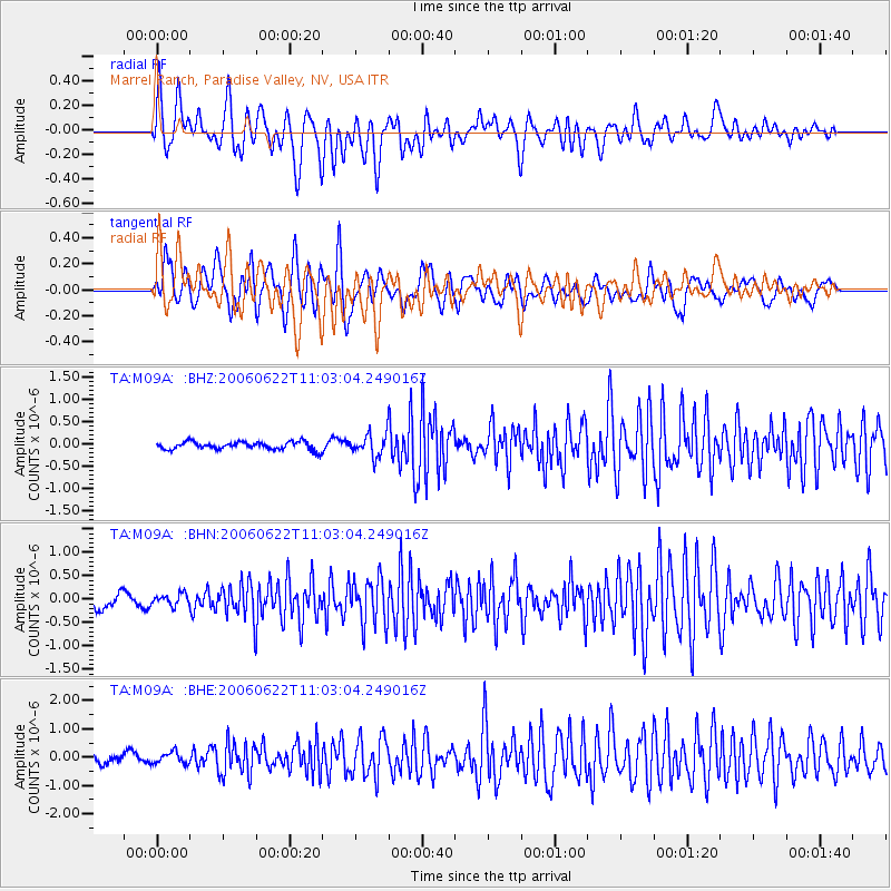
Signal To Noise
| Channel | StoN | STA | LTA |
| TA:M09A: :BHN:20060622T11:03:04.249016Z | 0.7947103 | 1.3370284E-7 | 1.6824099E-7 |
| TA:M09A: :BHE:20060622T11:03:04.249016Z | 1.2349011 | 2.0373349E-7 | 1.6497961E-7 |
| TA:M09A: :BHZ:20060622T11:03:04.249016Z | 2.8451152 | 2.5161273E-7 | 8.843674E-8 |
| Arrivals |
| Ps | 5.8 SECOND |
| PpPs | 15 SECOND |
| PsPs/PpSs | 21 SECOND |


