You are here: Home > Network List > TA - USArray Transportable Network (new EarthScope stations) Stations List
> Station M09A Marrel Ranch, Paradise Valley, NV, USA > Earthquake Result Viewer
M09A Marrel Ranch, Paradise Valley, NV, USA - Earthquake Result Viewer
| Earthquake location: |
Kermadec Islands Region |
| Earthquake latitude/longitude: |
-31.8/-179.3 |
| Earthquake time(UTC): |
2006/05/16 (136) 10:39:23 GMT |
| Earthquake Depth: |
152 km |
| Earthquake Magnitude: |
6.8 MB, 7.4 MW, 7.4 MW |
| Earthquake Catalog/Contributor: |
WHDF/NEIC |
|
| Network: |
TA USArray Transportable Network (new EarthScope stations) |
| Station: |
M09A Marrel Ranch, Paradise Valley, NV, USA |
| Lat/Lon: |
41.42 N/117.45 W |
| Elevation: |
1356 m |
|
| Distance: |
92.5 deg |
| Az: |
41.59 deg |
| Baz: |
228.74 deg |
| Ray Param: |
0.041361194 |
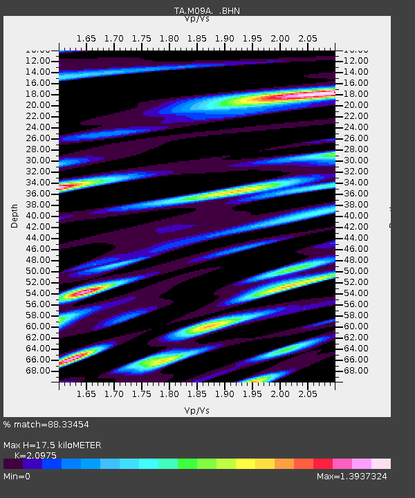
| Estimated Moho Depth: |
17.5 km |
| Estimated Crust Vp/Vs: |
2.10 |
| Assumed Crust Vp: |
6.276 km/s |
| Estimated Crust Vs: |
2.992 km/s |
| Estimated Crust Poisson's Ratio: |
0.35 |
|
| Radial Match: |
88.33454 % |
| Radial Bump: |
400 |
| Transverse Match: |
85.455666 % |
| Transverse Bump: |
400 |
| SOD ConfigId: |
2669 |
| Insert Time: |
2010-03-07 01:18:41.099 +0000 |
| GWidth: |
2.5 |
| Max Bumps: |
400 |
| Tol: |
0.001 |
|
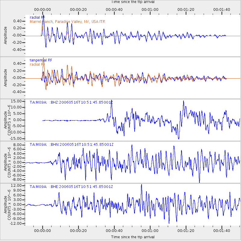
Signal To Noise
| Channel | StoN | STA | LTA |
| TA:M09A: :BHN:20060516T10:51:45.85001Z | 1.1781671 | 1.9330736E-7 | 1.6407465E-7 |
| TA:M09A: :BHE:20060516T10:51:45.85001Z | 1.5075217 | 3.358347E-7 | 2.2277271E-7 |
| TA:M09A: :BHZ:20060516T10:51:45.85001Z | 5.353789 | 7.1707245E-7 | 1.3393738E-7 |
| Arrivals |
| Ps | 3.1 SECOND |
| PpPs | 8.5 SECOND |
| PsPs/PpSs | 12 SECOND |


