You are here: Home > Network List > US - United States National Seismic Network Stations List
> Station MSO Missoula, Montana, USA > Earthquake Result Viewer
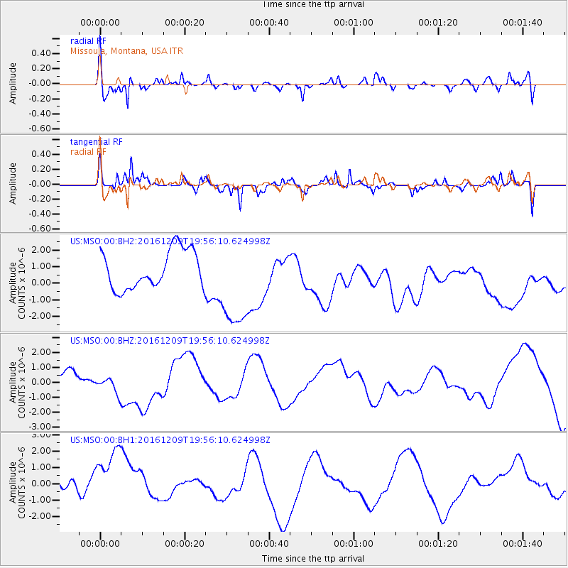
MSO Missoula, Montana, USA - Earthquake Result Viewer
*The percent match for this event was below the threshold and hence no stack was calculated.
| Earthquake location: |
Solomon Islands |
| Earthquake latitude/longitude: |
-11.0/161.3 |
| Earthquake time(UTC): |
2016/12/09 (344) 19:43:23 GMT |
| Earthquake Depth: |
18 km |
| Earthquake Magnitude: |
5.5 mb |
| Earthquake Catalog/Contributor: |
NEIC PDE/us |
|
| Network: |
US United States National Seismic Network |
| Station: |
MSO Missoula, Montana, USA |
| Lat/Lon: |
46.83 N/113.94 W |
| Elevation: |
1264 m |
|
| Distance: |
94.3 deg |
| Az: |
43.288 deg |
| Baz: |
258.702 deg |
| Ray Param: |
$rayparam |
*The percent match for this event was below the threshold and hence was not used in the summary stack. |
|
| Radial Match: |
68.410645 % |
| Radial Bump: |
381 |
| Transverse Match: |
61.969494 % |
| Transverse Bump: |
368 |
| SOD ConfigId: |
1894071 |
| Insert Time: |
2016-12-23 19:45:02.558 +0000 |
| GWidth: |
2.5 |
| Max Bumps: |
400 |
| Tol: |
0.001 |
|
Signal To Noise
| Channel | StoN | STA | LTA |
| US:MSO:00:BHZ:20161209T19:56:10.624998Z | 0.44635278 | 9.2639186E-7 | 2.07547E-6 |
| US:MSO:00:BH1:20161209T19:56:10.624998Z | 1.6400981 | 2.7428987E-6 | 1.6723991E-6 |
| US:MSO:00:BH2:20161209T19:56:10.624998Z | 2.5022643 | 2.884892E-6 | 1.1529127E-6 |
| Arrivals |
| Ps | |
| PpPs | |
| PsPs/PpSs | |


