You are here: Home > Network List > TA - USArray Transportable Network (new EarthScope stations) Stations List
> Station M09A Marrel Ranch, Paradise Valley, NV, USA > Earthquake Result Viewer
M09A Marrel Ranch, Paradise Valley, NV, USA - Earthquake Result Viewer
| Earthquake location: |
New Britain Region, P.N.G. |
| Earthquake latitude/longitude: |
-5.7/151.1 |
| Earthquake time(UTC): |
2006/05/28 (148) 03:12:08 GMT |
| Earthquake Depth: |
34 km |
| Earthquake Magnitude: |
5.9 MB, 6.6 MS, 6.5 MW, 6.4 MW |
| Earthquake Catalog/Contributor: |
WHDF/NEIC |
|
| Network: |
TA USArray Transportable Network (new EarthScope stations) |
| Station: |
M09A Marrel Ranch, Paradise Valley, NV, USA |
| Lat/Lon: |
41.42 N/117.45 W |
| Elevation: |
1356 m |
|
| Distance: |
94.8 deg |
| Az: |
48.979 deg |
| Baz: |
266.647 deg |
| Ray Param: |
0.040934555 |
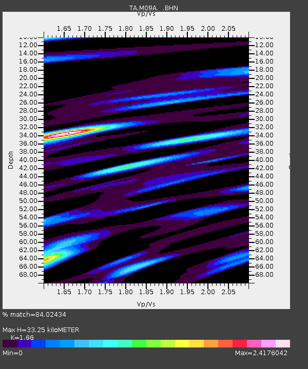
| Estimated Moho Depth: |
33.25 km |
| Estimated Crust Vp/Vs: |
1.66 |
| Assumed Crust Vp: |
6.276 km/s |
| Estimated Crust Vs: |
3.781 km/s |
| Estimated Crust Poisson's Ratio: |
0.22 |
|
| Radial Match: |
84.02434 % |
| Radial Bump: |
400 |
| Transverse Match: |
74.71744 % |
| Transverse Bump: |
400 |
| SOD ConfigId: |
2669 |
| Insert Time: |
2010-03-07 01:18:43.193 +0000 |
| GWidth: |
2.5 |
| Max Bumps: |
400 |
| Tol: |
0.001 |
|
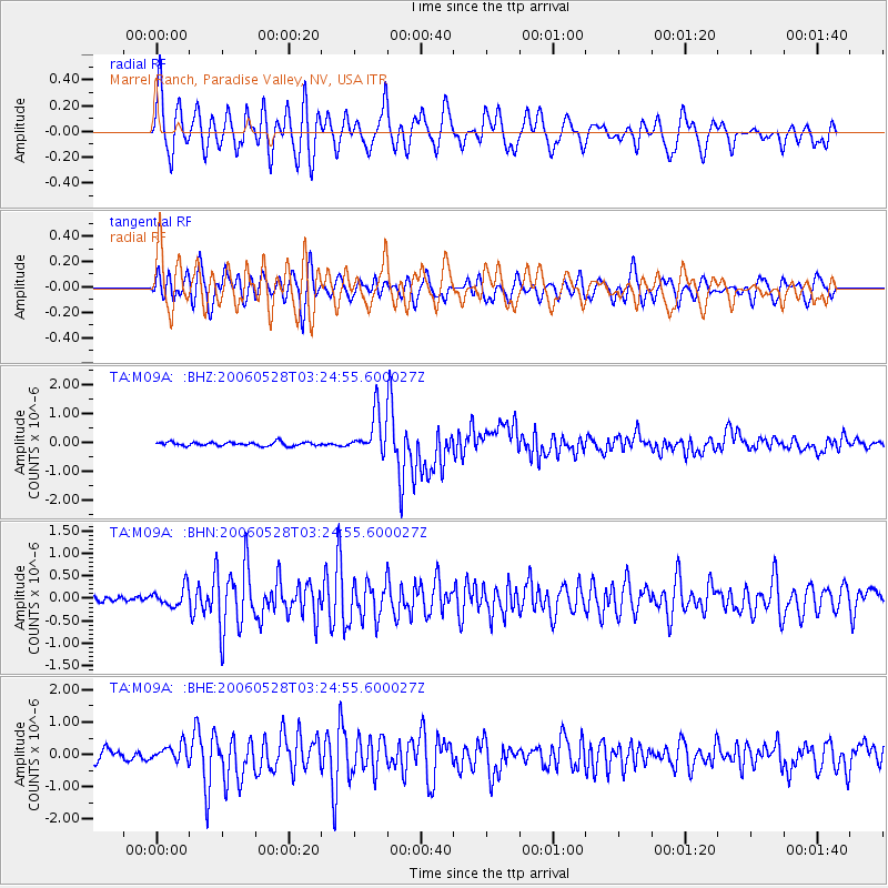
Signal To Noise
| Channel | StoN | STA | LTA |
| TA:M09A: :BHN:20060528T03:24:55.600027Z | 1.05662 | 2.0733687E-7 | 1.9622652E-7 |
| TA:M09A: :BHE:20060528T03:24:55.600027Z | 1.9835111 | 2.589317E-7 | 1.3054209E-7 |
| TA:M09A: :BHZ:20060528T03:24:55.600027Z | 11.11924 | 7.098681E-7 | 6.3841426E-8 |
| Arrivals |
| Ps | 3.6 SECOND |
| PpPs | 14 SECOND |
| PsPs/PpSs | 17 SECOND |


