You are here: Home > Network List > AT - Alaska Tsunami Warning Seismic System Stations List
> Station PMR Palmer, Alaska > Earthquake Result Viewer
PMR Palmer, Alaska - Earthquake Result Viewer
| Earthquake location: |
Northern Molucca Sea |
| Earthquake latitude/longitude: |
0.5/126.2 |
| Earthquake time(UTC): |
2019/07/07 (188) 15:08:40 GMT |
| Earthquake Depth: |
36 km |
| Earthquake Magnitude: |
6.9 Mww |
| Earthquake Catalog/Contributor: |
NEIC PDE/us |
|
| Network: |
AT Alaska Tsunami Warning Seismic System |
| Station: |
PMR Palmer, Alaska |
| Lat/Lon: |
61.59 N/149.13 W |
| Elevation: |
100 m |
|
| Distance: |
87.0 deg |
| Az: |
28.477 deg |
| Baz: |
265.564 deg |
| Ray Param: |
0.043593373 |
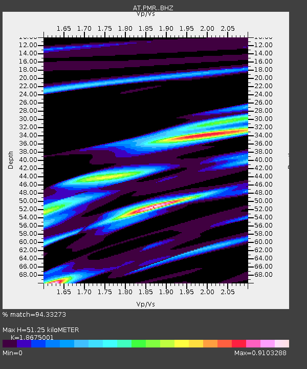
| Estimated Moho Depth: |
51.25 km |
| Estimated Crust Vp/Vs: |
1.87 |
| Assumed Crust Vp: |
6.566 km/s |
| Estimated Crust Vs: |
3.516 km/s |
| Estimated Crust Poisson's Ratio: |
0.30 |
|
| Radial Match: |
94.33273 % |
| Radial Bump: |
400 |
| Transverse Match: |
86.17201 % |
| Transverse Bump: |
400 |
| SOD ConfigId: |
19053131 |
| Insert Time: |
2019-07-21 15:10:23.238 +0000 |
| GWidth: |
2.5 |
| Max Bumps: |
400 |
| Tol: |
0.001 |
|

Signal To Noise
| Channel | StoN | STA | LTA |
| AT:PMR: :BHZ:20190707T15:20:50.939983Z | 17.429148 | 7.6528335E-7 | 4.3908248E-8 |
| AT:PMR: :BHN:20190707T15:20:50.939983Z | 3.3936777 | 1.1407346E-7 | 3.361352E-8 |
| AT:PMR: :BHE:20190707T15:20:50.939983Z | 5.8812304 | 3.1697235E-7 | 5.3895587E-8 |
| Arrivals |
| Ps | 6.9 SECOND |
| PpPs | 22 SECOND |
| PsPs/PpSs | 29 SECOND |


