You are here: Home > Network List > TA - USArray Transportable Network (new EarthScope stations) Stations List
> Station M06C Likely Place Golf, Likely, CA, USA > Earthquake Result Viewer
M06C Likely Place Golf, Likely, CA, USA - Earthquake Result Viewer

| Earthquake location: |
Near East Coast Of Honshu, Japan |
| Earthquake latitude/longitude: |
38.1/142.1 |
| Earthquake time(UTC): |
2005/12/02 (336) 13:13:09 GMT |
| Earthquake Depth: |
29 km |
| Earthquake Magnitude: |
6.1 MB, 6.3 MS, 6.5 MW, 6.4 MW |
| Earthquake Catalog/Contributor: |
WHDF/NEIC |
|
| Network: |
TA USArray Transportable Network (new EarthScope stations) |
| Station: |
M06C Likely Place Golf, Likely, CA, USA |
| Lat/Lon: |
41.21 N/120.48 W |
| Elevation: |
1434 m |
|
| Distance: |
70.9 deg |
| Az: |
52.338 deg |
| Baz: |
304.123 deg |
| Ray Param: |
0.054605275 |
| Estimated Moho Depth: |
10.0 km |
| Estimated Crust Vp/Vs: |
1.96 |
| Assumed Crust Vp: |
6.566 km/s |
| Estimated Crust Vs: |
3.359 km/s |
| Estimated Crust Poisson's Ratio: |
0.32 |
|
| Radial Match: |
80.03884 % |
| Radial Bump: |
400 |
| Transverse Match: |
65.79212 % |
| Transverse Bump: |
400 |
| SOD ConfigId: |
132717 |
| Insert Time: |
2010-03-07 01:18:53.079 +0000 |
| GWidth: |
2.5 |
| Max Bumps: |
400 |
| Tol: |
0.001 |
|
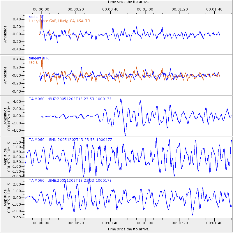
Signal To Noise
| Channel | StoN | STA | LTA |
| TA:M06C: :BHN:20051202T13:23:53.100017Z | 1.4505558 | 7.228779E-7 | 4.9834546E-7 |
| TA:M06C: :BHE:20051202T13:23:53.100017Z | 1.4306661 | 5.7172633E-7 | 3.9962248E-7 |
| TA:M06C: :BHZ:20051202T13:23:53.100017Z | 2.3486319 | 6.467652E-7 | 2.7537956E-7 |
| Arrivals |
| Ps | 1.5 SECOND |
| PpPs | 4.3 SECOND |
| PsPs/PpSs | 5.9 SECOND |


