You are here: Home > Network List > AV - Alaska Volcano Observatory Stations List
> Station ISLZ Lazaref River, Shishaldin Volcano, Alaska > Earthquake Result Viewer
ISLZ Lazaref River, Shishaldin Volcano, Alaska - Earthquake Result Viewer
| Earthquake location: |
Northern Molucca Sea |
| Earthquake latitude/longitude: |
0.5/126.2 |
| Earthquake time(UTC): |
2019/07/07 (188) 15:08:40 GMT |
| Earthquake Depth: |
36 km |
| Earthquake Magnitude: |
6.9 Mww |
| Earthquake Catalog/Contributor: |
NEIC PDE/us |
|
| Network: |
AV Alaska Volcano Observatory |
| Station: |
ISLZ Lazaref River, Shishaldin Volcano, Alaska |
| Lat/Lon: |
54.72 N/163.71 W |
| Elevation: |
634 m |
|
| Distance: |
78.2 deg |
| Az: |
33.865 deg |
| Baz: |
253.856 deg |
| Ray Param: |
0.049767785 |
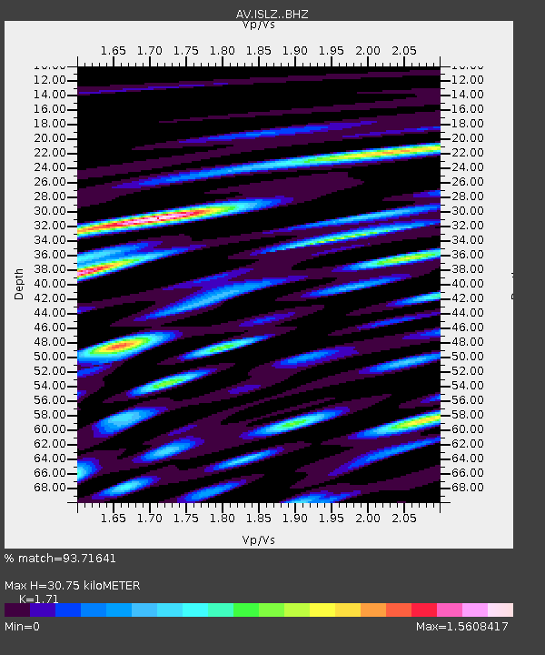
| Estimated Moho Depth: |
30.75 km |
| Estimated Crust Vp/Vs: |
1.71 |
| Assumed Crust Vp: |
5.989 km/s |
| Estimated Crust Vs: |
3.502 km/s |
| Estimated Crust Poisson's Ratio: |
0.24 |
|
| Radial Match: |
93.71641 % |
| Radial Bump: |
400 |
| Transverse Match: |
94.12166 % |
| Transverse Bump: |
400 |
| SOD ConfigId: |
19053131 |
| Insert Time: |
2019-07-21 15:10:58.531 +0000 |
| GWidth: |
2.5 |
| Max Bumps: |
400 |
| Tol: |
0.001 |
|

Signal To Noise
| Channel | StoN | STA | LTA |
| AV:ISLZ: :BHZ:20190707T15:20:05.220013Z | 6.8763328 | 1.6366504E-6 | 2.3801209E-7 |
| AV:ISLZ: :BHN:20190707T15:20:05.220013Z | 1.0778536 | 2.4531266E-7 | 2.2759366E-7 |
| AV:ISLZ: :BHE:20190707T15:20:05.220013Z | 1.9313632 | 5.0170036E-7 | 2.5976487E-7 |
| Arrivals |
| Ps | 3.7 SECOND |
| PpPs | 14 SECOND |
| PsPs/PpSs | 17 SECOND |


