You are here: Home > Network List > AV - Alaska Volcano Observatory Stations List
> Station MTBL Table Top, Makushin Volcano, Alaska > Earthquake Result Viewer
MTBL Table Top, Makushin Volcano, Alaska - Earthquake Result Viewer
| Earthquake location: |
Northern Molucca Sea |
| Earthquake latitude/longitude: |
0.5/126.2 |
| Earthquake time(UTC): |
2019/07/07 (188) 15:08:40 GMT |
| Earthquake Depth: |
36 km |
| Earthquake Magnitude: |
6.9 Mww |
| Earthquake Catalog/Contributor: |
NEIC PDE/us |
|
| Network: |
AV Alaska Volcano Observatory |
| Station: |
MTBL Table Top, Makushin Volcano, Alaska |
| Lat/Lon: |
53.97 N/166.68 W |
| Elevation: |
810 m |
|
| Distance: |
76.3 deg |
| Az: |
34.076 deg |
| Baz: |
251.496 deg |
| Ray Param: |
0.051039852 |
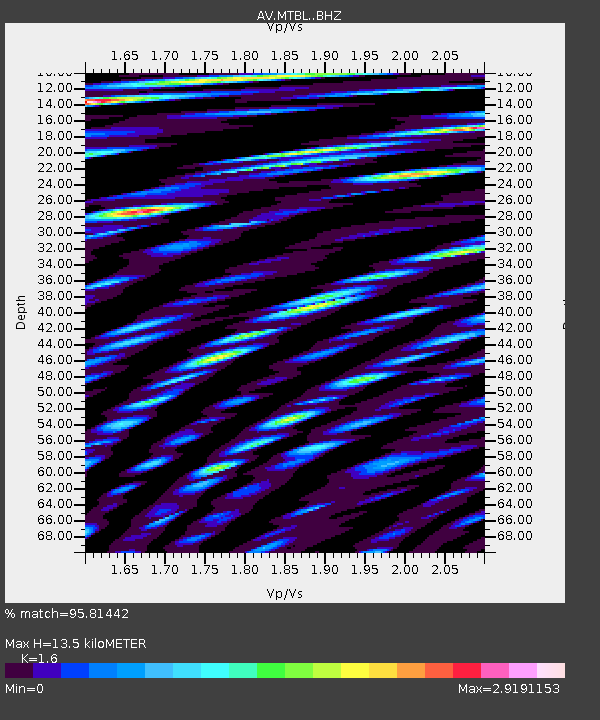
| Estimated Moho Depth: |
13.5 km |
| Estimated Crust Vp/Vs: |
1.60 |
| Assumed Crust Vp: |
3.943 km/s |
| Estimated Crust Vs: |
2.465 km/s |
| Estimated Crust Poisson's Ratio: |
0.18 |
|
| Radial Match: |
95.81442 % |
| Radial Bump: |
400 |
| Transverse Match: |
94.5551 % |
| Transverse Bump: |
400 |
| SOD ConfigId: |
19053131 |
| Insert Time: |
2019-07-21 15:11:02.071 +0000 |
| GWidth: |
2.5 |
| Max Bumps: |
400 |
| Tol: |
0.001 |
|

Signal To Noise
| Channel | StoN | STA | LTA |
| AV:MTBL: :BHZ:20190707T15:19:54.699993Z | 15.389948 | 4.7579183E-6 | 3.091575E-7 |
| AV:MTBL: :BHN:20190707T15:19:54.699993Z | 4.871097 | 3.3559743E-6 | 6.8895656E-7 |
| AV:MTBL: :BHE:20190707T15:19:54.699993Z | 3.5227625 | 2.6669097E-6 | 7.5705066E-7 |
| Arrivals |
| Ps | 2.1 SECOND |
| PpPs | 8.8 SECOND |
| PsPs/PpSs | 11 SECOND |


