You are here: Home > Network List > AV - Alaska Volcano Observatory Stations List
> Station GSIG Igitkin Island, Great Sitkin Volcano, Alaska > Earthquake Result Viewer
GSIG Igitkin Island, Great Sitkin Volcano, Alaska - Earthquake Result Viewer
| Earthquake location: |
Northern Molucca Sea |
| Earthquake latitude/longitude: |
0.5/126.2 |
| Earthquake time(UTC): |
2019/07/07 (188) 15:08:40 GMT |
| Earthquake Depth: |
36 km |
| Earthquake Magnitude: |
6.9 Mww |
| Earthquake Catalog/Contributor: |
NEIC PDE/us |
|
| Network: |
AV Alaska Volcano Observatory |
| Station: |
GSIG Igitkin Island, Great Sitkin Volcano, Alaska |
| Lat/Lon: |
51.99 N/175.93 W |
| Elevation: |
407 m |
|
| Distance: |
70.4 deg |
| Az: |
33.784 deg |
| Baz: |
244.041 deg |
| Ray Param: |
0.05497124 |
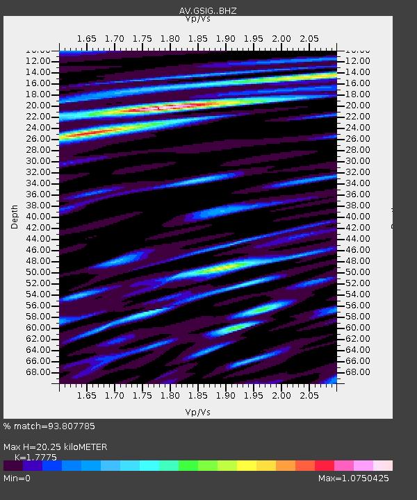
| Estimated Moho Depth: |
20.25 km |
| Estimated Crust Vp/Vs: |
1.78 |
| Assumed Crust Vp: |
3.943 km/s |
| Estimated Crust Vs: |
2.219 km/s |
| Estimated Crust Poisson's Ratio: |
0.27 |
|
| Radial Match: |
93.807785 % |
| Radial Bump: |
400 |
| Transverse Match: |
88.00366 % |
| Transverse Bump: |
400 |
| SOD ConfigId: |
19053131 |
| Insert Time: |
2019-07-21 15:11:22.834 +0000 |
| GWidth: |
2.5 |
| Max Bumps: |
400 |
| Tol: |
0.001 |
|
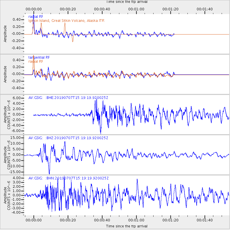
Signal To Noise
| Channel | StoN | STA | LTA |
| AV:GSIG: :BHZ:20190707T15:19:19.920025Z | 11.879456 | 1.6952933E-6 | 1.42708E-7 |
| AV:GSIG: :BHN:20190707T15:19:19.920025Z | 1.636383 | 3.817908E-7 | 2.3331383E-7 |
| AV:GSIG: :BHE:20190707T15:19:19.920025Z | 3.9522908 | 7.833093E-7 | 1.981912E-7 |
| Arrivals |
| Ps | 4.0 SECOND |
| PpPs | 14 SECOND |
| PsPs/PpSs | 18 SECOND |


