You are here: Home > Network List > AV - Alaska Volcano Observatory Stations List
> Station KIMD MID Benchmark, Kanaga Volcano, Alaska > Earthquake Result Viewer
KIMD MID Benchmark, Kanaga Volcano, Alaska - Earthquake Result Viewer
| Earthquake location: |
Northern Molucca Sea |
| Earthquake latitude/longitude: |
0.5/126.2 |
| Earthquake time(UTC): |
2019/07/07 (188) 15:08:40 GMT |
| Earthquake Depth: |
36 km |
| Earthquake Magnitude: |
6.9 Mww |
| Earthquake Catalog/Contributor: |
NEIC PDE/us |
|
| Network: |
AV Alaska Volcano Observatory |
| Station: |
KIMD MID Benchmark, Kanaga Volcano, Alaska |
| Lat/Lon: |
51.76 N/177.24 W |
| Elevation: |
183 m |
|
| Distance: |
69.5 deg |
| Az: |
33.612 deg |
| Baz: |
242.955 deg |
| Ray Param: |
0.05552022 |
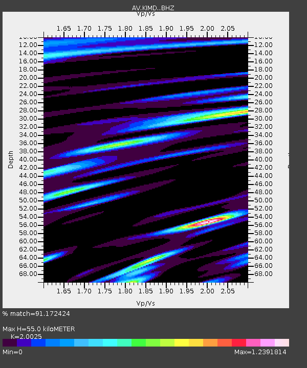
| Estimated Moho Depth: |
55.0 km |
| Estimated Crust Vp/Vs: |
2.00 |
| Assumed Crust Vp: |
5.88 km/s |
| Estimated Crust Vs: |
2.937 km/s |
| Estimated Crust Poisson's Ratio: |
0.33 |
|
| Radial Match: |
91.172424 % |
| Radial Bump: |
400 |
| Transverse Match: |
83.80506 % |
| Transverse Bump: |
400 |
| SOD ConfigId: |
19053131 |
| Insert Time: |
2019-07-21 15:11:26.185 +0000 |
| GWidth: |
2.5 |
| Max Bumps: |
400 |
| Tol: |
0.001 |
|

Signal To Noise
| Channel | StoN | STA | LTA |
| AV:KIMD: :BHZ:20190707T15:19:14.840008Z | 9.367921 | 1.5577099E-6 | 1.6628128E-7 |
| AV:KIMD: :BHN:20190707T15:19:14.840008Z | 1.7608914 | 2.8362425E-7 | 1.6106854E-7 |
| AV:KIMD: :BHE:20190707T15:19:14.840008Z | 2.428117 | 4.5994693E-7 | 1.8942536E-7 |
| Arrivals |
| Ps | 9.6 SECOND |
| PpPs | 27 SECOND |
| PsPs/PpSs | 37 SECOND |


