You are here: Home > Network List > AV - Alaska Volcano Observatory Stations List
> Station KIRH Round Head, Kanaga Volcano, Alaska > Earthquake Result Viewer
KIRH Round Head, Kanaga Volcano, Alaska - Earthquake Result Viewer
| Earthquake location: |
Northern Molucca Sea |
| Earthquake latitude/longitude: |
0.5/126.2 |
| Earthquake time(UTC): |
2019/07/07 (188) 15:08:40 GMT |
| Earthquake Depth: |
36 km |
| Earthquake Magnitude: |
6.9 Mww |
| Earthquake Catalog/Contributor: |
NEIC PDE/us |
|
| Network: |
AV Alaska Volcano Observatory |
| Station: |
KIRH Round Head, Kanaga Volcano, Alaska |
| Lat/Lon: |
51.90 N/177.09 W |
| Elevation: |
321 m |
|
| Distance: |
69.7 deg |
| Az: |
33.523 deg |
| Baz: |
243.036 deg |
| Ray Param: |
0.055425063 |
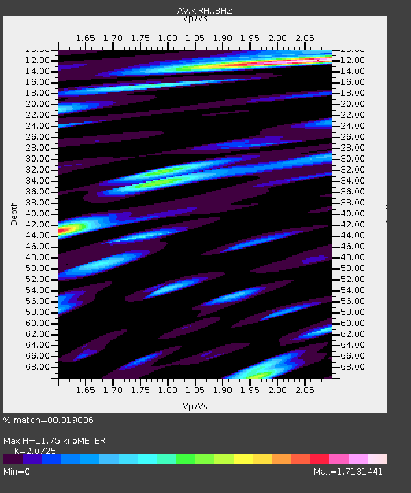
| Estimated Moho Depth: |
11.75 km |
| Estimated Crust Vp/Vs: |
2.07 |
| Assumed Crust Vp: |
5.88 km/s |
| Estimated Crust Vs: |
2.837 km/s |
| Estimated Crust Poisson's Ratio: |
0.35 |
|
| Radial Match: |
88.019806 % |
| Radial Bump: |
400 |
| Transverse Match: |
87.17372 % |
| Transverse Bump: |
400 |
| SOD ConfigId: |
19053131 |
| Insert Time: |
2019-07-21 15:11:27.408 +0000 |
| GWidth: |
2.5 |
| Max Bumps: |
400 |
| Tol: |
0.001 |
|

Signal To Noise
| Channel | StoN | STA | LTA |
| AV:KIRH: :BHZ:20190707T15:19:15.720013Z | 11.218742 | 2.0379605E-6 | 1.8165677E-7 |
| AV:KIRH: :BHN:20190707T15:19:15.720013Z | 1.8144683 | 5.249672E-7 | 2.893229E-7 |
| AV:KIRH: :BHE:20190707T15:19:15.720013Z | 2.250528 | 5.27819E-7 | 2.3453116E-7 |
| Arrivals |
| Ps | 2.2 SECOND |
| PpPs | 6.0 SECOND |
| PsPs/PpSs | 8.2 SECOND |


