You are here: Home > Network List > IU - Global Seismograph Network (GSN - IRIS/USGS) Stations List
> Station MAKZ Makanchi, Kazakhstan > Earthquake Result Viewer
MAKZ Makanchi, Kazakhstan - Earthquake Result Viewer

| Earthquake location: |
Northern Molucca Sea |
| Earthquake latitude/longitude: |
0.5/126.2 |
| Earthquake time(UTC): |
2019/07/07 (188) 15:08:40 GMT |
| Earthquake Depth: |
36 km |
| Earthquake Magnitude: |
6.9 Mww |
| Earthquake Catalog/Contributor: |
NEIC PDE/us |
|
| Network: |
IU Global Seismograph Network (GSN - IRIS/USGS) |
| Station: |
MAKZ Makanchi, Kazakhstan |
| Lat/Lon: |
46.81 N/81.98 E |
| Elevation: |
600 m |
|
| Distance: |
60.1 deg |
| Az: |
326.445 deg |
| Baz: |
126.421 deg |
| Ray Param: |
0.06170333 |
| Estimated Moho Depth: |
52.0 km |
| Estimated Crust Vp/Vs: |
1.73 |
| Assumed Crust Vp: |
6.571 km/s |
| Estimated Crust Vs: |
3.804 km/s |
| Estimated Crust Poisson's Ratio: |
0.25 |
|
| Radial Match: |
96.12486 % |
| Radial Bump: |
315 |
| Transverse Match: |
88.76759 % |
| Transverse Bump: |
400 |
| SOD ConfigId: |
19053131 |
| Insert Time: |
2019-07-21 15:12:18.569 +0000 |
| GWidth: |
2.5 |
| Max Bumps: |
400 |
| Tol: |
0.001 |
|
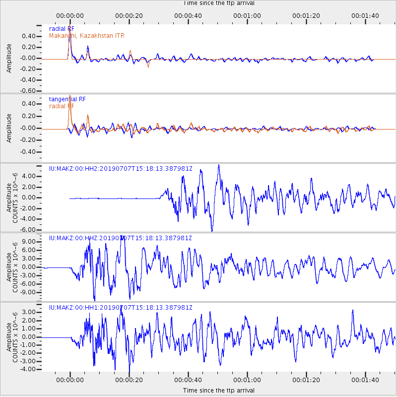
Signal To Noise
| Channel | StoN | STA | LTA |
| IU:MAKZ:00:HHZ:20190707T15:18:13.387981Z | 39.269035 | 1.891908E-6 | 4.8178112E-8 |
| IU:MAKZ:00:HH1:20190707T15:18:13.387981Z | 17.904007 | 4.9639203E-7 | 2.7725193E-8 |
| IU:MAKZ:00:HH2:20190707T15:18:13.387981Z | 33.619915 | 7.443195E-7 | 2.2139243E-8 |
| Arrivals |
| Ps | 6.1 SECOND |
| PpPs | 21 SECOND |
| PsPs/PpSs | 27 SECOND |


