You are here: Home > Network List > TA - USArray Transportable Network (new EarthScope stations) Stations List
> Station M06C Likely Place Golf, Likely, CA, USA > Earthquake Result Viewer
M06C Likely Place Golf, Likely, CA, USA - Earthquake Result Viewer
| Earthquake location: |
Near Coast Of Peru |
| Earthquake latitude/longitude: |
-13.6/-76.6 |
| Earthquake time(UTC): |
2007/08/17 (229) 13:18:13 GMT |
| Earthquake Depth: |
48 km |
| Earthquake Magnitude: |
5.6 MB, 5.6 MS, 5.9 MW |
| Earthquake Catalog/Contributor: |
WHDF/NEIC |
|
| Network: |
TA USArray Transportable Network (new EarthScope stations) |
| Station: |
M06C Likely Place Golf, Likely, CA, USA |
| Lat/Lon: |
41.21 N/120.48 W |
| Elevation: |
1434 m |
|
| Distance: |
67.9 deg |
| Az: |
325.649 deg |
| Baz: |
133.356 deg |
| Ray Param: |
0.05652725 |
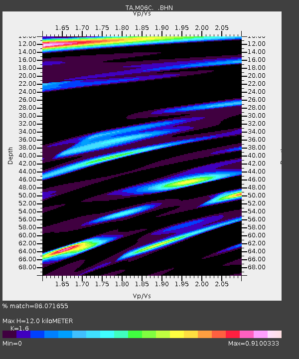
| Estimated Moho Depth: |
12.0 km |
| Estimated Crust Vp/Vs: |
1.60 |
| Assumed Crust Vp: |
6.566 km/s |
| Estimated Crust Vs: |
4.104 km/s |
| Estimated Crust Poisson's Ratio: |
0.18 |
|
| Radial Match: |
86.071655 % |
| Radial Bump: |
400 |
| Transverse Match: |
67.1827 % |
| Transverse Bump: |
400 |
| SOD ConfigId: |
2564 |
| Insert Time: |
2010-03-07 01:19:29.789 +0000 |
| GWidth: |
2.5 |
| Max Bumps: |
400 |
| Tol: |
0.001 |
|

Signal To Noise
| Channel | StoN | STA | LTA |
| TA:M06C: :BHN:20070817T13:28:36.199004Z | 2.2993321 | 1.5553373E-7 | 6.764301E-8 |
| TA:M06C: :BHE:20070817T13:28:36.199004Z | 2.2269459 | 2.573991E-7 | 1.15583916E-7 |
| TA:M06C: :BHZ:20070817T13:28:36.199004Z | 8.901468 | 7.4115087E-7 | 8.326165E-8 |
| Arrivals |
| Ps | 1.1 SECOND |
| PpPs | 4.5 SECOND |
| PsPs/PpSs | 5.7 SECOND |


