You are here: Home > Network List > TA - USArray Transportable Network (new EarthScope stations) Stations List
> Station M06C Likely Place Golf, Likely, CA, USA > Earthquake Result Viewer
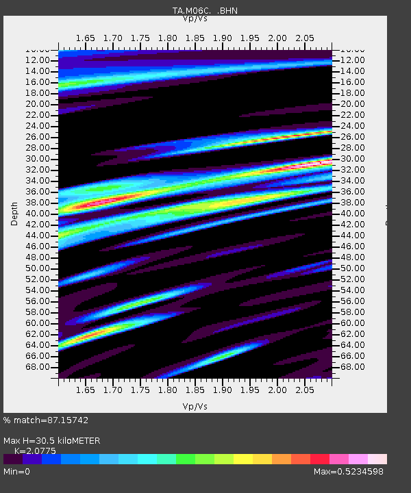
M06C Likely Place Golf, Likely, CA, USA - Earthquake Result Viewer
| Earthquake location: |
Southeast Of Loyalty Islands |
| Earthquake latitude/longitude: |
-21.5/170.9 |
| Earthquake time(UTC): |
2007/07/27 (208) 14:46:26 GMT |
| Earthquake Depth: |
10 km |
| Earthquake Magnitude: |
6.0 MB, 6.0 MS, 6.1 MW, 6.1 MW |
| Earthquake Catalog/Contributor: |
WHDF/NEIC |
|
| Network: |
TA USArray Transportable Network (new EarthScope stations) |
| Station: |
M06C Likely Place Golf, Likely, CA, USA |
| Lat/Lon: |
41.21 N/120.48 W |
| Elevation: |
1434 m |
|
| Distance: |
89.0 deg |
| Az: |
44.633 deg |
| Baz: |
240.15 deg |
| Ray Param: |
0.04219053 |
| Estimated Moho Depth: |
30.5 km |
| Estimated Crust Vp/Vs: |
2.08 |
| Assumed Crust Vp: |
6.566 km/s |
| Estimated Crust Vs: |
3.161 km/s |
| Estimated Crust Poisson's Ratio: |
0.35 |
|
| Radial Match: |
87.15742 % |
| Radial Bump: |
400 |
| Transverse Match: |
72.93935 % |
| Transverse Bump: |
400 |
| SOD ConfigId: |
2564 |
| Insert Time: |
2010-03-07 01:19:42.049 +0000 |
| GWidth: |
2.5 |
| Max Bumps: |
400 |
| Tol: |
0.001 |
|

Signal To Noise
| Channel | StoN | STA | LTA |
| TA:M06C: :BHN:20070727T14:58:50.098018Z | 1.347203 | 8.8177615E-8 | 6.5452355E-8 |
| TA:M06C: :BHE:20070727T14:58:50.098018Z | 1.5526636 | 1.2057652E-7 | 7.765785E-8 |
| TA:M06C: :BHZ:20070727T14:58:50.098018Z | 6.036933 | 3.9213867E-7 | 6.495661E-8 |
| Arrivals |
| Ps | 5.1 SECOND |
| PpPs | 14 SECOND |
| PsPs/PpSs | 19 SECOND |


