You are here: Home > Network List > TA - USArray Transportable Network (new EarthScope stations) Stations List
> Station M06C Likely Place Golf, Likely, CA, USA > Earthquake Result Viewer
M06C Likely Place Golf, Likely, CA, USA - Earthquake Result Viewer

| Earthquake location: |
Near West Coast Of Honshu, Japan |
| Earthquake latitude/longitude: |
37.5/138.4 |
| Earthquake time(UTC): |
2007/07/16 (197) 01:13:22 GMT |
| Earthquake Depth: |
12 km |
| Earthquake Magnitude: |
6.5 MB, 6.4 MS, 6.6 MW, 6.5 MW |
| Earthquake Catalog/Contributor: |
WHDF/NEIC |
|
| Network: |
TA USArray Transportable Network (new EarthScope stations) |
| Station: |
M06C Likely Place Golf, Likely, CA, USA |
| Lat/Lon: |
41.21 N/120.48 W |
| Elevation: |
1434 m |
|
| Distance: |
73.6 deg |
| Az: |
50.536 deg |
| Baz: |
305.574 deg |
| Ray Param: |
0.05291383 |
| Estimated Moho Depth: |
11.5 km |
| Estimated Crust Vp/Vs: |
1.60 |
| Assumed Crust Vp: |
6.566 km/s |
| Estimated Crust Vs: |
4.104 km/s |
| Estimated Crust Poisson's Ratio: |
0.18 |
|
| Radial Match: |
93.138054 % |
| Radial Bump: |
400 |
| Transverse Match: |
78.97135 % |
| Transverse Bump: |
400 |
| SOD ConfigId: |
2564 |
| Insert Time: |
2010-03-07 01:19:51.810 +0000 |
| GWidth: |
2.5 |
| Max Bumps: |
400 |
| Tol: |
0.001 |
|
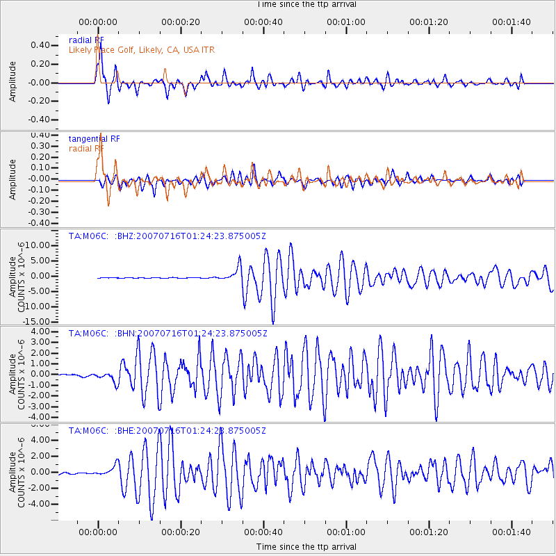
Signal To Noise
| Channel | StoN | STA | LTA |
| TA:M06C: :BHN:20070716T01:24:23.875005Z | 4.9434805 | 5.035368E-7 | 1.0185876E-7 |
| TA:M06C: :BHE:20070716T01:24:23.875005Z | 7.07754 | 6.8721596E-7 | 9.709814E-8 |
| TA:M06C: :BHZ:20070716T01:24:23.875005Z | 30.56033 | 2.4289202E-6 | 7.947951E-8 |
| Arrivals |
| Ps | 1.1 SECOND |
| PpPs | 4.4 SECOND |
| PsPs/PpSs | 5.5 SECOND |


