You are here: Home > Network List > TA - USArray Transportable Network (new EarthScope stations) Stations List
> Station B20K Meade River, AK, USA > Earthquake Result Viewer
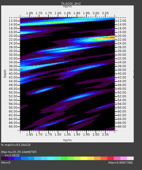
B20K Meade River, AK, USA - Earthquake Result Viewer
| Earthquake location: |
Northern Molucca Sea |
| Earthquake latitude/longitude: |
0.5/126.2 |
| Earthquake time(UTC): |
2019/07/07 (188) 15:08:40 GMT |
| Earthquake Depth: |
36 km |
| Earthquake Magnitude: |
6.9 Mww |
| Earthquake Catalog/Contributor: |
NEIC PDE/us |
|
| Network: |
TA USArray Transportable Network (new EarthScope stations) |
| Station: |
B20K Meade River, AK, USA |
| Lat/Lon: |
70.01 N/157.16 W |
| Elevation: |
75 m |
|
| Distance: |
85.0 deg |
| Az: |
19.628 deg |
| Baz: |
257.604 deg |
| Ray Param: |
0.045062203 |
| Estimated Moho Depth: |
20.25 km |
| Estimated Crust Vp/Vs: |
2.09 |
| Assumed Crust Vp: |
6.048 km/s |
| Estimated Crust Vs: |
2.89 km/s |
| Estimated Crust Poisson's Ratio: |
0.35 |
|
| Radial Match: |
93.06428 % |
| Radial Bump: |
400 |
| Transverse Match: |
90.472206 % |
| Transverse Bump: |
400 |
| SOD ConfigId: |
19053131 |
| Insert Time: |
2019-07-21 15:13:28.831 +0000 |
| GWidth: |
2.5 |
| Max Bumps: |
400 |
| Tol: |
0.001 |
|

Signal To Noise
| Channel | StoN | STA | LTA |
| TA:B20K: :BHZ:20190707T15:20:40.900005Z | 4.5760226 | 7.26038E-7 | 1.5866136E-7 |
| TA:B20K: :BHN:20190707T15:20:40.900005Z | 0.57905334 | 6.379588E-8 | 1.10172714E-7 |
| TA:B20K: :BHE:20190707T15:20:40.900005Z | 1.4184784 | 1.5478196E-7 | 1.09118304E-7 |
| Arrivals |
| Ps | 3.7 SECOND |
| PpPs | 10 SECOND |
| PsPs/PpSs | 14 SECOND |


