You are here: Home > Network List > TA - USArray Transportable Network (new EarthScope stations) Stations List
> Station C18K Utukok River, AK, USA > Earthquake Result Viewer
C18K Utukok River, AK, USA - Earthquake Result Viewer
| Earthquake location: |
Northern Molucca Sea |
| Earthquake latitude/longitude: |
0.5/126.2 |
| Earthquake time(UTC): |
2019/07/07 (188) 15:08:40 GMT |
| Earthquake Depth: |
36 km |
| Earthquake Magnitude: |
6.9 Mww |
| Earthquake Catalog/Contributor: |
NEIC PDE/us |
|
| Network: |
TA USArray Transportable Network (new EarthScope stations) |
| Station: |
C18K Utukok River, AK, USA |
| Lat/Lon: |
68.65 N/161.19 W |
| Elevation: |
845 m |
|
| Distance: |
83.2 deg |
| Az: |
20.605 deg |
| Baz: |
253.933 deg |
| Ray Param: |
0.04628575 |
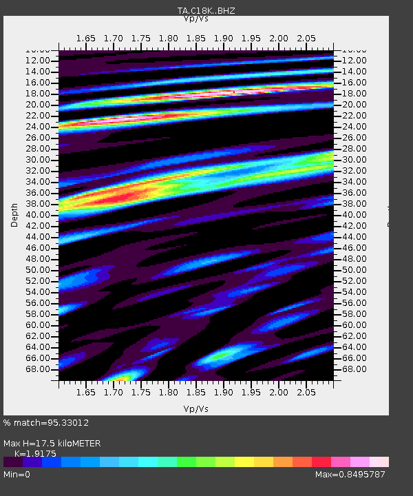
| Estimated Moho Depth: |
17.5 km |
| Estimated Crust Vp/Vs: |
1.92 |
| Assumed Crust Vp: |
5.906 km/s |
| Estimated Crust Vs: |
3.08 km/s |
| Estimated Crust Poisson's Ratio: |
0.31 |
|
| Radial Match: |
95.33012 % |
| Radial Bump: |
400 |
| Transverse Match: |
96.28368 % |
| Transverse Bump: |
400 |
| SOD ConfigId: |
19053131 |
| Insert Time: |
2019-07-21 15:13:32.002 +0000 |
| GWidth: |
2.5 |
| Max Bumps: |
400 |
| Tol: |
0.001 |
|

Signal To Noise
| Channel | StoN | STA | LTA |
| TA:C18K: :BHZ:20190707T15:20:32.150005Z | 8.915219 | 7.3090536E-7 | 8.1984E-8 |
| TA:C18K: :BHN:20190707T15:20:32.150005Z | 1.7183486 | 1.3923632E-7 | 8.102915E-8 |
| TA:C18K: :BHE:20190707T15:20:32.150005Z | 2.1903374 | 1.710743E-7 | 7.810409E-8 |
| Arrivals |
| Ps | 2.8 SECOND |
| PpPs | 8.5 SECOND |
| PsPs/PpSs | 11 SECOND |


