You are here: Home > Network List > TA - USArray Transportable Network (new EarthScope stations) Stations List
> Station C27K Jago River, AK, USA > Earthquake Result Viewer
C27K Jago River, AK, USA - Earthquake Result Viewer
| Earthquake location: |
Northern Molucca Sea |
| Earthquake latitude/longitude: |
0.5/126.2 |
| Earthquake time(UTC): |
2019/07/07 (188) 15:08:40 GMT |
| Earthquake Depth: |
36 km |
| Earthquake Magnitude: |
6.9 Mww |
| Earthquake Catalog/Contributor: |
NEIC PDE/us |
|
| Network: |
TA USArray Transportable Network (new EarthScope stations) |
| Station: |
C27K Jago River, AK, USA |
| Lat/Lon: |
69.63 N/143.71 W |
| Elevation: |
392 m |
|
| Distance: |
89.5 deg |
| Az: |
20.501 deg |
| Baz: |
270.265 deg |
| Ray Param: |
0.04173245 |
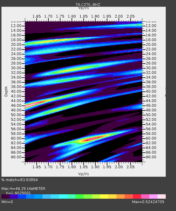
| Estimated Moho Depth: |
46.25 km |
| Estimated Crust Vp/Vs: |
1.60 |
| Assumed Crust Vp: |
6.522 km/s |
| Estimated Crust Vs: |
4.07 km/s |
| Estimated Crust Poisson's Ratio: |
0.18 |
|
| Radial Match: |
93.93954 % |
| Radial Bump: |
395 |
| Transverse Match: |
87.35565 % |
| Transverse Bump: |
400 |
| SOD ConfigId: |
19053131 |
| Insert Time: |
2019-07-21 15:13:35.140 +0000 |
| GWidth: |
2.5 |
| Max Bumps: |
400 |
| Tol: |
0.001 |
|

Signal To Noise
| Channel | StoN | STA | LTA |
| TA:C27K: :BHZ:20190707T15:21:02.999981Z | 12.008868 | 5.8436405E-7 | 4.866104E-8 |
| TA:C27K: :BHN:20190707T15:21:02.999981Z | 1.6937636 | 6.809812E-8 | 4.0205208E-8 |
| TA:C27K: :BHE:20190707T15:21:02.999981Z | 3.1296647 | 1.2060173E-7 | 3.853503E-8 |
| Arrivals |
| Ps | 4.4 SECOND |
| PpPs | 18 SECOND |
| PsPs/PpSs | 22 SECOND |


