You are here: Home > Network List > TA - USArray Transportable Network (new EarthScope stations) Stations List
> Station M06C Likely Place Golf, Likely, CA, USA > Earthquake Result Viewer
M06C Likely Place Golf, Likely, CA, USA - Earthquake Result Viewer
| Earthquake location: |
East Of Kuril Islands |
| Earthquake latitude/longitude: |
46.2/154.5 |
| Earthquake time(UTC): |
2007/01/13 (013) 04:23:21 GMT |
| Earthquake Depth: |
10 km |
| Earthquake Magnitude: |
7.3 MB, 8.2 MS, 8.1 MW, 7.9 MW |
| Earthquake Catalog/Contributor: |
WHDF/NEIC |
|
| Network: |
TA USArray Transportable Network (new EarthScope stations) |
| Station: |
M06C Likely Place Golf, Likely, CA, USA |
| Lat/Lon: |
41.21 N/120.48 W |
| Elevation: |
1434 m |
|
| Distance: |
58.8 deg |
| Az: |
61.502 deg |
| Baz: |
306.066 deg |
| Ray Param: |
0.06261246 |
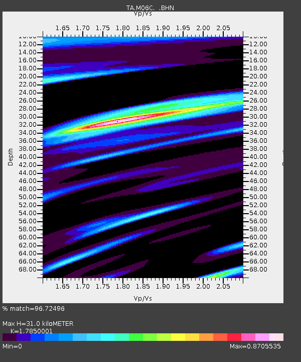
| Estimated Moho Depth: |
31.0 km |
| Estimated Crust Vp/Vs: |
1.79 |
| Assumed Crust Vp: |
6.566 km/s |
| Estimated Crust Vs: |
3.679 km/s |
| Estimated Crust Poisson's Ratio: |
0.27 |
|
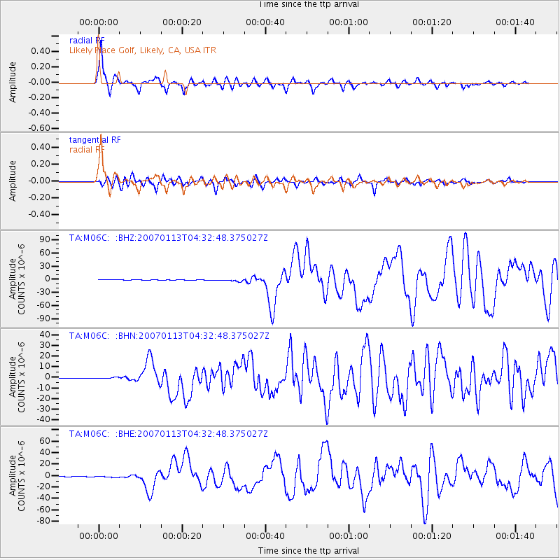
| Radial Match: |
96.72496 % |
| Radial Bump: |
400 |
| Transverse Match: |
88.85286 % |
| Transverse Bump: |
400 |
| SOD ConfigId: |
2564 |
| Insert Time: |
2010-03-07 01:20:07.232 +0000 |
| GWidth: |
2.5 |
| Max Bumps: |
400 |
| Tol: |
0.001 |
|
Signal To Noise
| Channel | StoN | STA | LTA |
| TA:M06C: :BHN:20070113T04:32:48.375027Z | 3.7037113 | 8.220691E-7 | 2.219582E-7 |
| TA:M06C: :BHE:20070113T04:32:48.375027Z | 5.3394055 | 1.1493687E-6 | 2.1526155E-7 |
| TA:M06C: :BHZ:20070113T04:32:48.375027Z | 11.067772 | 2.561844E-6 | 2.314688E-7 |
| Arrivals |
| Ps | 3.9 SECOND |
| PpPs | 13 SECOND |
| PsPs/PpSs | 16 SECOND |


