You are here: Home > Network List > TA - USArray Transportable Network (new EarthScope stations) Stations List
> Station HARP HAARP, Gakona, AK, USA > Earthquake Result Viewer
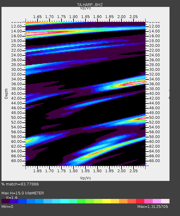
HARP HAARP, Gakona, AK, USA - Earthquake Result Viewer
| Earthquake location: |
Northern Molucca Sea |
| Earthquake latitude/longitude: |
0.5/126.2 |
| Earthquake time(UTC): |
2019/07/07 (188) 15:08:40 GMT |
| Earthquake Depth: |
36 km |
| Earthquake Magnitude: |
6.9 Mww |
| Earthquake Catalog/Contributor: |
NEIC PDE/us |
|
| Network: |
TA USArray Transportable Network (new EarthScope stations) |
| Station: |
HARP HAARP, Gakona, AK, USA |
| Lat/Lon: |
62.40 N/145.16 W |
| Elevation: |
581 m |
|
| Distance: |
88.9 deg |
| Az: |
27.757 deg |
| Baz: |
269.042 deg |
| Ray Param: |
0.042188004 |
| Estimated Moho Depth: |
15.0 km |
| Estimated Crust Vp/Vs: |
1.60 |
| Assumed Crust Vp: |
6.566 km/s |
| Estimated Crust Vs: |
4.104 km/s |
| Estimated Crust Poisson's Ratio: |
0.18 |
|
| Radial Match: |
83.77886 % |
| Radial Bump: |
400 |
| Transverse Match: |
81.55795 % |
| Transverse Bump: |
400 |
| SOD ConfigId: |
19053131 |
| Insert Time: |
2019-07-21 15:14:11.879 +0000 |
| GWidth: |
2.5 |
| Max Bumps: |
400 |
| Tol: |
0.001 |
|

Signal To Noise
| Channel | StoN | STA | LTA |
| TA:HARP: :BHZ:20190707T15:21:00.05003Z | 4.391394 | 5.7539916E-7 | 1.3102881E-7 |
| TA:HARP: :BHN:20190707T15:21:00.05003Z | 0.55431485 | 1.3092928E-7 | 2.3620021E-7 |
| TA:HARP: :BHE:20190707T15:21:00.05003Z | 1.6416914 | 1.9908099E-7 | 1.2126578E-7 |
| Arrivals |
| Ps | 1.4 SECOND |
| PpPs | 5.8 SECOND |
| PsPs/PpSs | 7.2 SECOND |


