You are here: Home > Network List > TA - USArray Transportable Network (new EarthScope stations) Stations List
> Station I23K Minto, Yukon-Koyukuk, AK, USA > Earthquake Result Viewer
I23K Minto, Yukon-Koyukuk, AK, USA - Earthquake Result Viewer
| Earthquake location: |
Northern Molucca Sea |
| Earthquake latitude/longitude: |
0.5/126.2 |
| Earthquake time(UTC): |
2019/07/07 (188) 15:08:40 GMT |
| Earthquake Depth: |
36 km |
| Earthquake Magnitude: |
6.9 Mww |
| Earthquake Catalog/Contributor: |
NEIC PDE/us |
|
| Network: |
TA USArray Transportable Network (new EarthScope stations) |
| Station: |
I23K Minto, Yukon-Koyukuk, AK, USA |
| Lat/Lon: |
65.15 N/149.36 W |
| Elevation: |
149 m |
|
| Distance: |
87.2 deg |
| Az: |
24.906 deg |
| Baz: |
265.177 deg |
| Ray Param: |
0.043457877 |
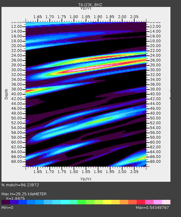
| Estimated Moho Depth: |
29.25 km |
| Estimated Crust Vp/Vs: |
1.85 |
| Assumed Crust Vp: |
6.566 km/s |
| Estimated Crust Vs: |
3.554 km/s |
| Estimated Crust Poisson's Ratio: |
0.29 |
|
| Radial Match: |
96.23972 % |
| Radial Bump: |
400 |
| Transverse Match: |
91.77848 % |
| Transverse Bump: |
400 |
| SOD ConfigId: |
19053131 |
| Insert Time: |
2019-07-21 15:14:13.496 +0000 |
| GWidth: |
2.5 |
| Max Bumps: |
400 |
| Tol: |
0.001 |
|
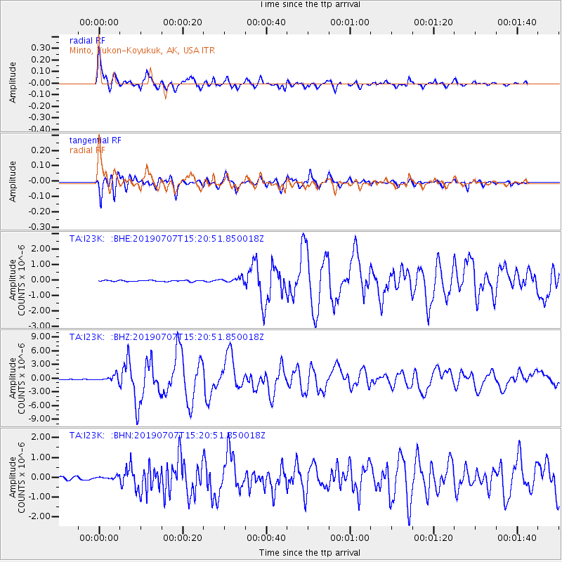
Signal To Noise
| Channel | StoN | STA | LTA |
| TA:I23K: :BHZ:20190707T15:20:51.850018Z | 18.301054 | 6.939784E-7 | 3.7920135E-8 |
| TA:I23K: :BHN:20190707T15:20:51.850018Z | 1.0420878 | 7.6137525E-8 | 7.306248E-8 |
| TA:I23K: :BHE:20190707T15:20:51.850018Z | 4.416632 | 1.6194116E-7 | 3.666621E-8 |
| Arrivals |
| Ps | 3.9 SECOND |
| PpPs | 12 SECOND |
| PsPs/PpSs | 16 SECOND |


