You are here: Home > Network List > TA - USArray Transportable Network (new EarthScope stations) Stations List
> Station I26K Coal Creek Mining Camp, AK, USA > Earthquake Result Viewer
I26K Coal Creek Mining Camp, AK, USA - Earthquake Result Viewer
| Earthquake location: |
Northern Molucca Sea |
| Earthquake latitude/longitude: |
0.5/126.2 |
| Earthquake time(UTC): |
2019/07/07 (188) 15:08:40 GMT |
| Earthquake Depth: |
36 km |
| Earthquake Magnitude: |
6.9 Mww |
| Earthquake Catalog/Contributor: |
NEIC PDE/us |
|
| Network: |
TA USArray Transportable Network (new EarthScope stations) |
| Station: |
I26K Coal Creek Mining Camp, AK, USA |
| Lat/Lon: |
65.31 N/143.15 W |
| Elevation: |
338 m |
|
| Distance: |
89.8 deg |
| Az: |
24.838 deg |
| Baz: |
270.805 deg |
| Ray Param: |
0.04171423 |
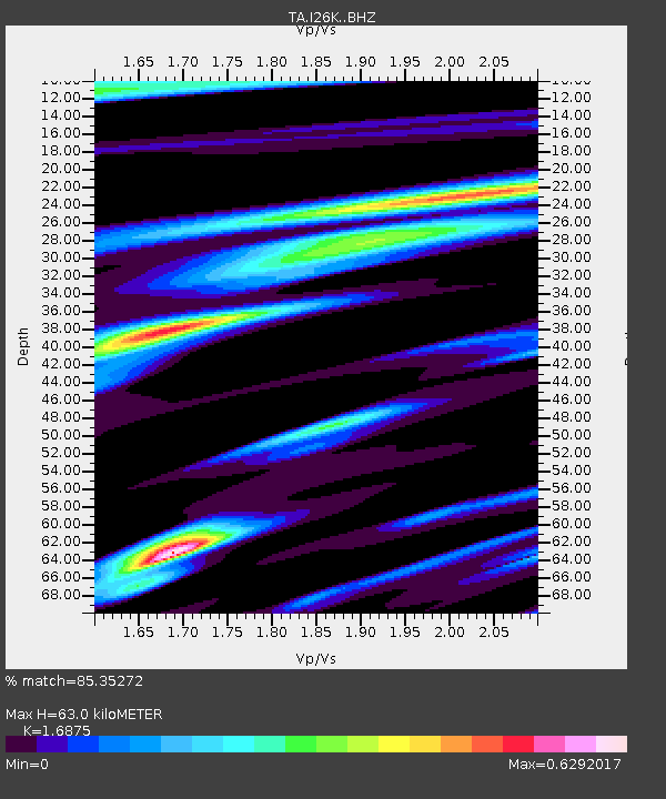
| Estimated Moho Depth: |
63.0 km |
| Estimated Crust Vp/Vs: |
1.69 |
| Assumed Crust Vp: |
6.566 km/s |
| Estimated Crust Vs: |
3.891 km/s |
| Estimated Crust Poisson's Ratio: |
0.23 |
|
| Radial Match: |
85.35272 % |
| Radial Bump: |
400 |
| Transverse Match: |
82.00361 % |
| Transverse Bump: |
400 |
| SOD ConfigId: |
19053131 |
| Insert Time: |
2019-07-21 15:14:13.530 +0000 |
| GWidth: |
2.5 |
| Max Bumps: |
400 |
| Tol: |
0.001 |
|

Signal To Noise
| Channel | StoN | STA | LTA |
| TA:I26K: :BHZ:20190707T15:21:04.199993Z | 12.471588 | 4.599855E-7 | 3.6882675E-8 |
| TA:I26K: :BHN:20190707T15:21:04.199993Z | 1.3766237 | 8.785581E-8 | 6.381976E-8 |
| TA:I26K: :BHE:20190707T15:21:04.199993Z | 3.6844769 | 1.5541336E-7 | 4.2180577E-8 |
| Arrivals |
| Ps | 6.7 SECOND |
| PpPs | 25 SECOND |
| PsPs/PpSs | 32 SECOND |


