You are here: Home > Network List > TA - USArray Transportable Network (new EarthScope stations) Stations List
> Station L19K White Mountain, AK, USA > Earthquake Result Viewer
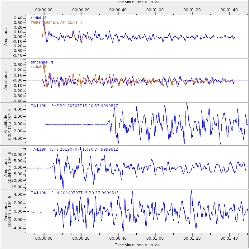
L19K White Mountain, AK, USA - Earthquake Result Viewer
| Earthquake location: |
Northern Molucca Sea |
| Earthquake latitude/longitude: |
0.5/126.2 |
| Earthquake time(UTC): |
2019/07/07 (188) 15:08:40 GMT |
| Earthquake Depth: |
36 km |
| Earthquake Magnitude: |
6.9 Mww |
| Earthquake Catalog/Contributor: |
NEIC PDE/us |
|
| Network: |
TA USArray Transportable Network (new EarthScope stations) |
| Station: |
L19K White Mountain, AK, USA |
| Lat/Lon: |
62.18 N/154.85 W |
| Elevation: |
650 m |
|
| Distance: |
84.4 deg |
| Az: |
27.558 deg |
| Baz: |
260.453 deg |
| Ray Param: |
0.04547428 |
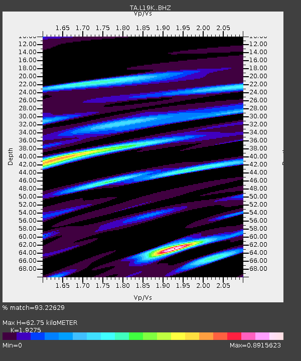
| Estimated Moho Depth: |
62.75 km |
| Estimated Crust Vp/Vs: |
1.93 |
| Assumed Crust Vp: |
6.438 km/s |
| Estimated Crust Vs: |
3.34 km/s |
| Estimated Crust Poisson's Ratio: |
0.32 |
|
| Radial Match: |
93.22629 % |
| Radial Bump: |
400 |
| Transverse Match: |
84.231636 % |
| Transverse Bump: |
400 |
| SOD ConfigId: |
19053131 |
| Insert Time: |
2019-07-21 15:14:28.774 +0000 |
| GWidth: |
2.5 |
| Max Bumps: |
400 |
| Tol: |
0.001 |
|
Signal To Noise
| Channel | StoN | STA | LTA |
| TA:L19K: :BHZ:20190707T15:20:37.999981Z | 9.705072 | 5.029975E-7 | 5.1828312E-8 |
| TA:L19K: :BHN:20190707T15:20:37.999981Z | 0.5863252 | 4.3615376E-8 | 7.438768E-8 |
| TA:L19K: :BHE:20190707T15:20:37.999981Z | 3.6218035 | 1.6854338E-7 | 4.6535764E-8 |
| Arrivals |
| Ps | 9.2 SECOND |
| PpPs | 28 SECOND |
| PsPs/PpSs | 37 SECOND |


