You are here: Home > Network List > TA - USArray Transportable Network (new EarthScope stations) Stations List
> Station P08K Saint George Island, AK, USA > Earthquake Result Viewer
P08K Saint George Island, AK, USA - Earthquake Result Viewer
| Earthquake location: |
Northern Molucca Sea |
| Earthquake latitude/longitude: |
0.5/126.2 |
| Earthquake time(UTC): |
2019/07/07 (188) 15:08:40 GMT |
| Earthquake Depth: |
36 km |
| Earthquake Magnitude: |
6.9 Mww |
| Earthquake Catalog/Contributor: |
NEIC PDE/us |
|
| Network: |
TA USArray Transportable Network (new EarthScope stations) |
| Station: |
P08K Saint George Island, AK, USA |
| Lat/Lon: |
56.60 N/169.55 W |
| Elevation: |
36 m |
|
| Distance: |
75.7 deg |
| Az: |
30.942 deg |
| Baz: |
248.384 deg |
| Ray Param: |
0.051468395 |
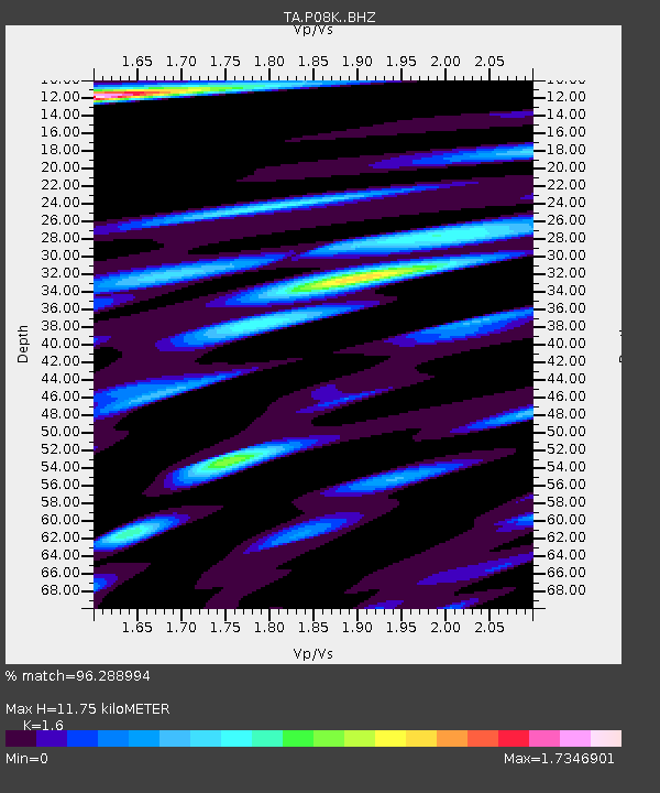
| Estimated Moho Depth: |
11.75 km |
| Estimated Crust Vp/Vs: |
1.60 |
| Assumed Crust Vp: |
6.24 km/s |
| Estimated Crust Vs: |
3.9 km/s |
| Estimated Crust Poisson's Ratio: |
0.18 |
|
| Radial Match: |
96.288994 % |
| Radial Bump: |
400 |
| Transverse Match: |
90.94046 % |
| Transverse Bump: |
400 |
| SOD ConfigId: |
19053131 |
| Insert Time: |
2019-07-21 15:14:53.362 +0000 |
| GWidth: |
2.5 |
| Max Bumps: |
400 |
| Tol: |
0.001 |
|

Signal To Noise
| Channel | StoN | STA | LTA |
| TA:P08K: :BHZ:20190707T15:19:51.074993Z | 2.6611464 | 8.9440545E-7 | 3.3609783E-7 |
| TA:P08K: :BHN:20190707T15:19:51.074993Z | 1.2599332 | 6.450395E-7 | 5.1196326E-7 |
| TA:P08K: :BHE:20190707T15:19:51.074993Z | 2.1058762 | 8.16685E-7 | 3.8781246E-7 |
| Arrivals |
| Ps | 1.2 SECOND |
| PpPs | 4.7 SECOND |
| PsPs/PpSs | 5.9 SECOND |


