You are here: Home > Network List > TA - USArray Transportable Network (new EarthScope stations) Stations List
> Station P16K Nushagak River, AK, USA > Earthquake Result Viewer
P16K Nushagak River, AK, USA - Earthquake Result Viewer
| Earthquake location: |
Northern Molucca Sea |
| Earthquake latitude/longitude: |
0.5/126.2 |
| Earthquake time(UTC): |
2019/07/07 (188) 15:08:40 GMT |
| Earthquake Depth: |
36 km |
| Earthquake Magnitude: |
6.9 Mww |
| Earthquake Catalog/Contributor: |
NEIC PDE/us |
|
| Network: |
TA USArray Transportable Network (new EarthScope stations) |
| Station: |
P16K Nushagak River, AK, USA |
| Lat/Lon: |
59.03 N/157.99 W |
| Elevation: |
86 m |
|
| Distance: |
82.3 deg |
| Az: |
30.393 deg |
| Baz: |
258.053 deg |
| Ray Param: |
0.046953 |
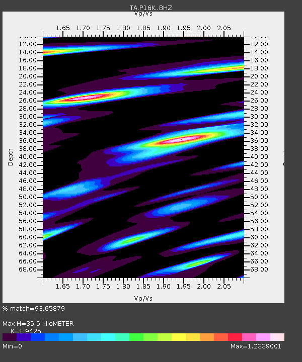
| Estimated Moho Depth: |
35.5 km |
| Estimated Crust Vp/Vs: |
1.94 |
| Assumed Crust Vp: |
6.276 km/s |
| Estimated Crust Vs: |
3.231 km/s |
| Estimated Crust Poisson's Ratio: |
0.32 |
|
| Radial Match: |
93.65879 % |
| Radial Bump: |
400 |
| Transverse Match: |
95.414986 % |
| Transverse Bump: |
400 |
| SOD ConfigId: |
19053131 |
| Insert Time: |
2019-07-21 15:14:54.200 +0000 |
| GWidth: |
2.5 |
| Max Bumps: |
400 |
| Tol: |
0.001 |
|

Signal To Noise
| Channel | StoN | STA | LTA |
| TA:P16K: :BHZ:20190707T15:20:27.199993Z | 10.928482 | 1.2064728E-6 | 1.103971E-7 |
| TA:P16K: :BHN:20190707T15:20:27.199993Z | 1.101527 | 1.6549168E-7 | 1.5023844E-7 |
| TA:P16K: :BHE:20190707T15:20:27.199993Z | 0.9799667 | 1.495519E-7 | 1.5260918E-7 |
| Arrivals |
| Ps | 5.5 SECOND |
| PpPs | 16 SECOND |
| PsPs/PpSs | 22 SECOND |


