You are here: Home > Network List > TA - USArray Transportable Network (new EarthScope stations) Stations List
> Station R17L Mt. Peulik Volcano, AVO PLK4, AK, USA > Earthquake Result Viewer
R17L Mt. Peulik Volcano, AVO PLK4, AK, USA - Earthquake Result Viewer
| Earthquake location: |
Northern Molucca Sea |
| Earthquake latitude/longitude: |
0.5/126.2 |
| Earthquake time(UTC): |
2019/07/07 (188) 15:08:40 GMT |
| Earthquake Depth: |
36 km |
| Earthquake Magnitude: |
6.9 Mww |
| Earthquake Catalog/Contributor: |
NEIC PDE/us |
|
| Network: |
TA USArray Transportable Network (new EarthScope stations) |
| Station: |
R17L Mt. Peulik Volcano, AVO PLK4, AK, USA |
| Lat/Lon: |
57.63 N/156.36 W |
| Elevation: |
524 m |
|
| Distance: |
82.8 deg |
| Az: |
31.95 deg |
| Baz: |
259.64 deg |
| Ray Param: |
0.0465559 |
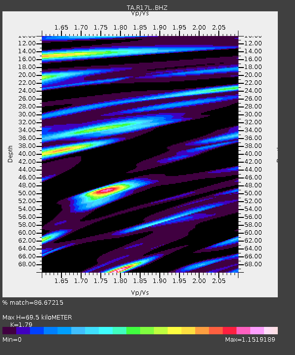
| Estimated Moho Depth: |
69.5 km |
| Estimated Crust Vp/Vs: |
1.79 |
| Assumed Crust Vp: |
6.1 km/s |
| Estimated Crust Vs: |
3.408 km/s |
| Estimated Crust Poisson's Ratio: |
0.27 |
|
| Radial Match: |
86.67215 % |
| Radial Bump: |
400 |
| Transverse Match: |
77.43655 % |
| Transverse Bump: |
400 |
| SOD ConfigId: |
19053131 |
| Insert Time: |
2019-07-21 15:15:03.113 +0000 |
| GWidth: |
2.5 |
| Max Bumps: |
400 |
| Tol: |
0.001 |
|

Signal To Noise
| Channel | StoN | STA | LTA |
| TA:R17L: :BHZ:20190707T15:20:30.150005Z | 18.789375 | 2.2221745E-6 | 1.18267614E-7 |
| TA:R17L: :BHN:20190707T15:20:30.150005Z | 3.1355984 | 3.2023846E-7 | 1.0212993E-7 |
| TA:R17L: :BHE:20190707T15:20:30.150005Z | 6.3251305 | 8.7952816E-7 | 1.3905297E-7 |
| Arrivals |
| Ps | 9.2 SECOND |
| PpPs | 31 SECOND |
| PsPs/PpSs | 40 SECOND |


