You are here: Home > Network List > TA - USArray Transportable Network (new EarthScope stations) Stations List
> Station S14K Fog Glacier, AK, USA > Earthquake Result Viewer
S14K Fog Glacier, AK, USA - Earthquake Result Viewer
| Earthquake location: |
Northern Molucca Sea |
| Earthquake latitude/longitude: |
0.5/126.2 |
| Earthquake time(UTC): |
2019/07/07 (188) 15:08:40 GMT |
| Earthquake Depth: |
36 km |
| Earthquake Magnitude: |
6.9 Mww |
| Earthquake Catalog/Contributor: |
NEIC PDE/us |
|
| Network: |
TA USArray Transportable Network (new EarthScope stations) |
| Station: |
S14K Fog Glacier, AK, USA |
| Lat/Lon: |
56.28 N/159.55 W |
| Elevation: |
1059 m |
|
| Distance: |
80.9 deg |
| Az: |
32.93 deg |
| Baz: |
257.107 deg |
| Ray Param: |
0.04794166 |
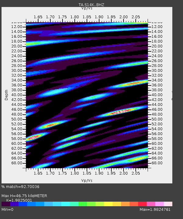
| Estimated Moho Depth: |
46.75 km |
| Estimated Crust Vp/Vs: |
1.98 |
| Assumed Crust Vp: |
6.134 km/s |
| Estimated Crust Vs: |
3.094 km/s |
| Estimated Crust Poisson's Ratio: |
0.33 |
|
| Radial Match: |
92.70036 % |
| Radial Bump: |
400 |
| Transverse Match: |
85.48109 % |
| Transverse Bump: |
400 |
| SOD ConfigId: |
19053131 |
| Insert Time: |
2019-07-21 15:15:05.061 +0000 |
| GWidth: |
2.5 |
| Max Bumps: |
400 |
| Tol: |
0.001 |
|

Signal To Noise
| Channel | StoN | STA | LTA |
| TA:S14K: :BHZ:20190707T15:20:19.749981Z | 14.332348 | 3.00267E-6 | 2.09503E-7 |
| TA:S14K: :BHN:20190707T15:20:19.749981Z | 1.9965347 | 5.3940704E-7 | 2.7017163E-7 |
| TA:S14K: :BHE:20190707T15:20:19.749981Z | 1.3315581 | 4.1171592E-7 | 3.091986E-7 |
| Arrivals |
| Ps | 7.7 SECOND |
| PpPs | 22 SECOND |
| PsPs/PpSs | 30 SECOND |


