You are here: Home > Network List > TA - USArray Transportable Network (new EarthScope stations) Stations List
> Station N09A Rock Creek Ranch, Golconda, NV, USA > Earthquake Result Viewer
N09A Rock Creek Ranch, Golconda, NV, USA - Earthquake Result Viewer
| Earthquake location: |
Northern Chile |
| Earthquake latitude/longitude: |
-22.2/-69.9 |
| Earthquake time(UTC): |
2007/11/14 (318) 15:40:50 GMT |
| Earthquake Depth: |
40 km |
| Earthquake Magnitude: |
6.7 MB, 7.4 MS, 7.7 MW, 7.4 ME |
| Earthquake Catalog/Contributor: |
WHDF/NEIC |
|
| Network: |
TA USArray Transportable Network (new EarthScope stations) |
| Station: |
N09A Rock Creek Ranch, Golconda, NV, USA |
| Lat/Lon: |
40.85 N/117.52 W |
| Elevation: |
1617 m |
|
| Distance: |
76.8 deg |
| Az: |
324.853 deg |
| Baz: |
135.325 deg |
| Ray Param: |
0.050684642 |
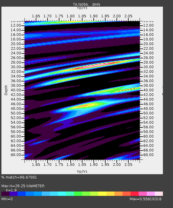
| Estimated Moho Depth: |
29.25 km |
| Estimated Crust Vp/Vs: |
1.90 |
| Assumed Crust Vp: |
6.276 km/s |
| Estimated Crust Vs: |
3.303 km/s |
| Estimated Crust Poisson's Ratio: |
0.31 |
|
| Radial Match: |
96.67881 % |
| Radial Bump: |
400 |
| Transverse Match: |
90.12058 % |
| Transverse Bump: |
400 |
| SOD ConfigId: |
2564 |
| Insert Time: |
2010-03-07 01:21:02.798 +0000 |
| GWidth: |
2.5 |
| Max Bumps: |
400 |
| Tol: |
0.001 |
|

Signal To Noise
| Channel | StoN | STA | LTA |
| TA:N09A: :BHN:20071114T15:52:07.074006Z | 11.479994 | 9.0995576E-7 | 7.926448E-8 |
| TA:N09A: :BHE:20071114T15:52:07.074006Z | 6.841389 | 8.3845464E-7 | 1.2255619E-7 |
| TA:N09A: :BHZ:20071114T15:52:07.074006Z | 17.06257 | 3.3026563E-6 | 1.9356148E-7 |
| Arrivals |
| Ps | 4.3 SECOND |
| PpPs | 13 SECOND |
| PsPs/PpSs | 17 SECOND |


