You are here: Home > Network List > TA - USArray Transportable Network (new EarthScope stations) Stations List
> Station N09A Rock Creek Ranch, Golconda, NV, USA > Earthquake Result Viewer
N09A Rock Creek Ranch, Golconda, NV, USA - Earthquake Result Viewer
| Earthquake location: |
Southeast Of Loyalty Islands |
| Earthquake latitude/longitude: |
-21.2/169.4 |
| Earthquake time(UTC): |
2007/09/28 (271) 01:01:48 GMT |
| Earthquake Depth: |
10 km |
| Earthquake Magnitude: |
5.8 MB, 6.4 MS, 6.3 MW, 6.2 MW |
| Earthquake Catalog/Contributor: |
WHDF/NEIC |
|
| Network: |
TA USArray Transportable Network (new EarthScope stations) |
| Station: |
N09A Rock Creek Ranch, Golconda, NV, USA |
| Lat/Lon: |
40.85 N/117.52 W |
| Elevation: |
1617 m |
|
| Distance: |
91.6 deg |
| Az: |
46.566 deg |
| Baz: |
243.284 deg |
| Ray Param: |
0.041578285 |
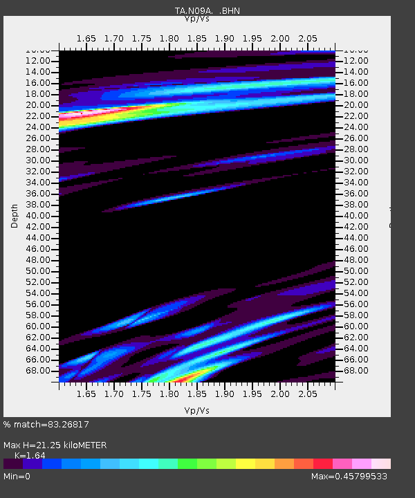
| Estimated Moho Depth: |
21.25 km |
| Estimated Crust Vp/Vs: |
1.64 |
| Assumed Crust Vp: |
6.276 km/s |
| Estimated Crust Vs: |
3.827 km/s |
| Estimated Crust Poisson's Ratio: |
0.20 |
|
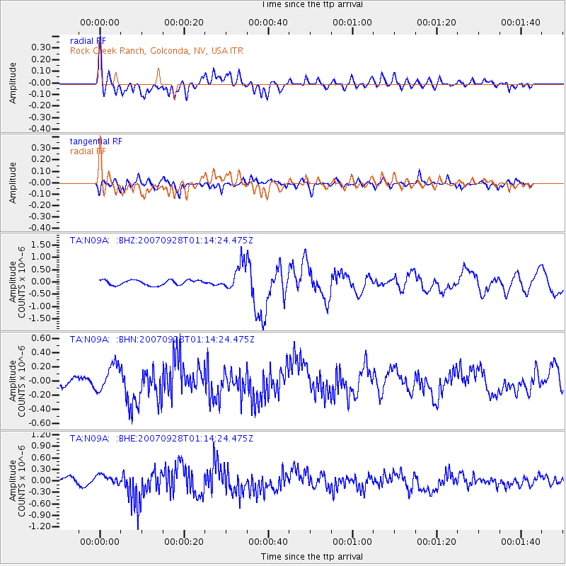
| Radial Match: |
83.26817 % |
| Radial Bump: |
400 |
| Transverse Match: |
72.4983 % |
| Transverse Bump: |
400 |
| SOD ConfigId: |
2564 |
| Insert Time: |
2010-03-07 01:21:11.719 +0000 |
| GWidth: |
2.5 |
| Max Bumps: |
400 |
| Tol: |
0.001 |
|
Signal To Noise
| Channel | StoN | STA | LTA |
| TA:N09A: :BHN:20070928T01:14:24.475Z | 2.4505055 | 1.9137926E-7 | 7.809787E-8 |
| TA:N09A: :BHE:20070928T01:14:24.475Z | 1.1146473 | 1.308589E-7 | 1.1739937E-7 |
| TA:N09A: :BHZ:20070928T01:14:24.475Z | 5.4739113 | 5.6461937E-7 | 1.0314734E-7 |
| Arrivals |
| Ps | 2.2 SECOND |
| PpPs | 8.8 SECOND |
| PsPs/PpSs | 11 SECOND |


